Photographic Print > Europe > France > Canton > Landes
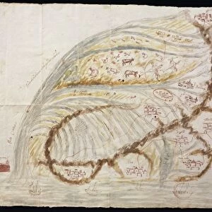
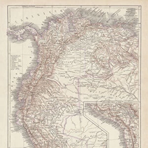
Photographic Print : Peru, Ecuador, Colombia, Venezuela, lithograph, published in 1877


![]()
Photo Prints from Fine Art Storehouse
Peru, Ecuador, Colombia, Venezuela, lithograph, published in 1877
Ancient map of Peru, Ecuador, Colombia, and Venezuela. Lithograph, published in 1877
Unleash your creativity and transform your space into a visual masterpiece!
Media ID 13666767
© ZU_09
Colombia Contour Drawing Country Geographic Area Ecuador Fax Machine Land Peru South America The Americas Topographic Map Topography Venezuela World Map Colombian Culture
10"x8" (25x20cm) Photo Print
Step back in time with this stunning lithographic print from the Media Storehouse collection. This ancient map, published in 1877, captures the beauty and intrigue of Peru, Ecuador, Colombia, and Venezuela. With meticulous attention to detail, the artists of the time meticulously depicted the landscapes, geography, and borders of these South American countries. This collectible piece of history is not only a beautiful addition to any home or office, but also a conversation starter and a reminder of the rich history and culture of the region. Bring a piece of the past into your present with this exquisite lithograph from Fine Art Storehouse.
Printed on archival quality paper for unrivalled stable artwork permanence and brilliant colour reproduction with accurate colour rendition and smooth tones. Printed on professional 234gsm Fujifilm Crystal Archive DP II paper. 10x8 for landscape images, 8x10 for portrait images.
Our Photo Prints are in a large range of sizes and are printed on Archival Quality Paper for excellent colour reproduction and longevity. They are ideal for framing (our Framed Prints use these) at a reasonable cost. Alternatives include cheaper Poster Prints and higher quality Fine Art Paper, the choice of which is largely dependant on your budget.
Estimated Product Size is 20.3cm x 25.4cm (8" x 10")
These are individually made so all sizes are approximate
Artwork printed orientated as per the preview above, with portrait (vertical) orientation to match the source image.
FEATURES IN THESE COLLECTIONS
> Fine Art Storehouse
> Map
> Historical Maps
> Europe
> France
> Canton
> Landes
> Maps and Charts
> Early Maps
> Maps and Charts
> Related Images
> Maps and Charts
> World
> South America
> Colombia
> Maps
> South America
> Colombia
> Related Images
> South America
> Ecuador
> Maps
> South America
> Ecuador
> Related Images
> South America
> Peru
> Maps
EDITORS COMMENTS
This lithograph, published in 1877, takes us on a journey through the rich history and topography of Peru, Ecuador, Colombia, and Venezuela. The ancient map showcases the intricate details of these South American countries with its engraved images and contour drawings. As we gaze upon this antique print, we are transported back in time to an era when cartography was both a science and an art form. The vertical composition allows us to explore the vast landscapes that make up these nations - from the majestic Andes Mountains to the sprawling Amazon rainforest. The meticulous craftsmanship of this lithograph reveals not only the geographical features but also provides insights into cultural aspects. It offers glimpses into Colombian traditions and Peruvian heritage while highlighting Ecuadorian landmarks. This historical document serves as a testament to the diverse tapestry of cultures that have shaped this region over centuries. Despite being created over a century ago, this image continues to captivate viewers today. Its timeless appeal lies in its ability to transport us across borders and connect us with our shared human history. Whether displayed in homes or educational institutions, it serves as a reminder of how maps can bridge gaps between generations by preserving knowledge for future exploration.
MADE IN THE UK
Safe Shipping with 30 Day Money Back Guarantee
FREE PERSONALISATION*
We are proud to offer a range of customisation features including Personalised Captions, Color Filters and Picture Zoom Tools
SECURE PAYMENTS
We happily accept a wide range of payment options so you can pay for the things you need in the way that is most convenient for you
* Options may vary by product and licensing agreement. Zoomed Pictures can be adjusted in the Basket.