Photographic Print > Asia > Related Images
Photographic Print : Map of Middle East - illustration


![]()
Photo Prints from Fine Art Storehouse
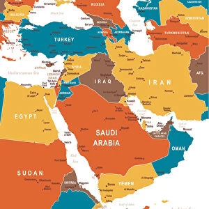
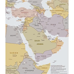
Map of Middle East - illustration
Colored Map of Middle East Asia with Country Names and Capital Cities
Unleash your creativity and transform your space into a visual masterpiece!
Media ID 13880193
10"x8" (25x20cm) Photo Print
Discover the captivating beauty of the Middle East with our exquisite "Map of Middle East - Illustration" from the Media Storehouse Fine Art collection. This vibrant and intricately detailed colored map showcases the diverse regions and countries of the Middle East, each accompanied by its respective capital city. Perfect for adding a touch of geographical elegance to your home or office, this fine art print is a must-have for world travelers, history enthusiasts, or anyone with a passion for exploration. Bring a piece of the rich Middle Eastern culture into your space with this stunning and thoughtfully designed artwork.
Printed on archival quality paper for unrivalled stable artwork permanence and brilliant colour reproduction with accurate colour rendition and smooth tones. Printed on professional 234gsm Fujifilm Crystal Archive DP II paper. 10x8 for landscape images, 8x10 for portrait images.
Our Photo Prints are in a large range of sizes and are printed on Archival Quality Paper for excellent colour reproduction and longevity. They are ideal for framing (our Framed Prints use these) at a reasonable cost. Alternatives include cheaper Poster Prints and higher quality Fine Art Paper, the choice of which is largely dependant on your budget.
Estimated Product Size is 20.3cm x 25.4cm (8" x 10")
These are individually made so all sizes are approximate
Artwork printed orientated as per the preview above, with portrait (vertical) orientation to match the source image.
FEATURES IN THESE COLLECTIONS
> Fine Art Storehouse
> Map
> Historical Maps
> Asia
> Related Images
> Maps and Charts
> Related Images
EDITORS COMMENTS
Vibrant Hues of the Middle East: A Colorful Journey through Countries and Capitals This and intricately detailed Map of the Middle East, with its rich hues and bold outlines, invites us on an enchanting exploration of the diverse lands and vibrant cultures that make up this fascinating region. The map, a beautiful illustration from the Fine Art Storehouse, showcases the Middle East in all its complexity, with each country represented in a distinct color and its capital city marked with a regal crown. From the sun-kissed shores of the Arabian Peninsula to the ancient lands of Iran and Iraq, the map transports us on a visual journey through the heart of the Middle East. The Sinai Peninsula, a bridge between Africa and Asia, is depicted in a warm, golden hue, while the verdant hills of Lebanon and Syria are rendered in lush greens. The arid expanses of the Empty Quarter in Arabia are contrasted by the irrigated oases that dot the region, creating a stunning tapestry of color and texture. Each capital city is marked with a regal crown, adding a touch of majesty to the map. The ancient city of Damascus, Syria, shines in a rich, red hue, while the modern metropolis of Dubai, United Arab Emirates, sparkles in gold. The map serves as a testament to the rich history and diverse cultures that have shaped the Middle East, making it an essential addition to any world map collection. This Map of the Middle East is not only a work of art but also an educational tool, providing a visual representation of the region's geography, borders, and political divisions. It is a must-have for anyone with a passion for travel, history, or geography, and a beautiful reminder of the vibrant and complex world we live in.
MADE IN THE UK
Safe Shipping with 30 Day Money Back Guarantee
FREE PERSONALISATION*
We are proud to offer a range of customisation features including Personalised Captions, Color Filters and Picture Zoom Tools
SECURE PAYMENTS
We happily accept a wide range of payment options so you can pay for the things you need in the way that is most convenient for you
* Options may vary by product and licensing agreement. Zoomed Pictures can be adjusted in the Basket.