Photographic Print > North America > Canada > Maps
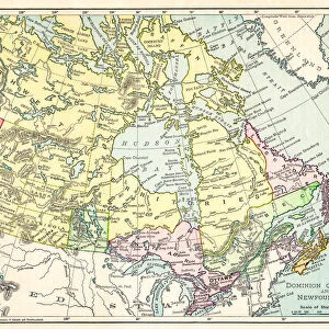
Photographic Print : Dominion of Canada map 1877


![]()
Photo Prints from Fine Art Storehouse
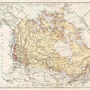
Dominion of Canada map 1877
Warrens Common School Geography 1877
Unleash your creativity and transform your space into a visual masterpiece!
THEPALMER
Media ID 14824563
© This content is subject to copyright
Alberta British British Columbia Canada North America Nova Scotia Ontario Quebec Manitoba New Brunswick Saskatchewan
10"x8" (25x20cm) Photo Print
Step back in time with this stunning historical print from Media Storehouse's Fine Art Storehouse collection. Featuring the Dominion of Canada map from 1877, this print is a beautiful representation of the geography of the time, as depicted in Warrens Common School Geography. The intricate details and vibrant colors bring the map to life, making it a captivating addition to any home or office. Printed on high-quality archival paper, this print is not only a work of art but also a piece of history that can be cherished for generations. Order yours today and let this piece of Canadian history tell a story in your space.
Printed on archival quality paper for unrivalled stable artwork permanence and brilliant colour reproduction with accurate colour rendition and smooth tones. Printed on professional 234gsm Fujifilm Crystal Archive DP II paper. 10x8 for landscape images, 8x10 for portrait images.
Our Photo Prints are in a large range of sizes and are printed on Archival Quality Paper for excellent colour reproduction and longevity. They are ideal for framing (our Framed Prints use these) at a reasonable cost. Alternatives include cheaper Poster Prints and higher quality Fine Art Paper, the choice of which is largely dependant on your budget.
Estimated Product Size is 25.4cm x 20.3cm (10" x 8")
These are individually made so all sizes are approximate
Artwork printed orientated as per the preview above, with landscape (horizontal) orientation to match the source image.
FEATURES IN THESE COLLECTIONS
> Fine Art Storehouse
> Map
> Historical Maps
> Maps and Charts
> Related Images
> North America
> Canada
> Maps
> North America
> Canada
> Related Images
> North America
> Related Images
EDITORS COMMENTS
This print showcases the Dominion of Canada map from 1877, taken from Warrens Common School Geography. The intricate details and historical significance captured in this image transport us back to a time when the Canadian landscape was still being explored and settled. The map encompasses various provinces and territories that form the foundation of modern-day Canada. From Alberta to British Columbia, Manitoba to New Brunswick, Newfoundland to Nova Scotia, Ontario to Quebec, and Saskatchewan - each region is meticulously outlined with precision. As we gaze upon this piece of artistry by THEPALMER from Fine Art Storehouse, we are reminded of the vastness and diversity that defines North America's second-largest country. The rich colors used in this print bring life to every corner of the Dominion while evoking a sense of adventure and discovery. Beyond its aesthetic appeal, this photograph serves as an educational tool for those interested in understanding Canada's history and geographical evolution over time. It invites viewers on a journey through centuries past when borders were being drawn, settlements were established, and new frontiers awaited exploration. Whether displayed in homes or educational institutions alike, this remarkable print offers not only visual delight but also sparks curiosity about our nation's roots. Its presence is a testament to the enduring legacy left by those who shaped Canada into what it is today – a land filled with diverse cultures united under one flag: maple leaf proudly adorning their hearts.
MADE IN THE UK
Safe Shipping with 30 Day Money Back Guarantee
FREE PERSONALISATION*
We are proud to offer a range of customisation features including Personalised Captions, Color Filters and Picture Zoom Tools
SECURE PAYMENTS
We happily accept a wide range of payment options so you can pay for the things you need in the way that is most convenient for you
* Options may vary by product and licensing agreement. Zoomed Pictures can be adjusted in the Basket.