Photographic Print > Maps and Charts > Related Images
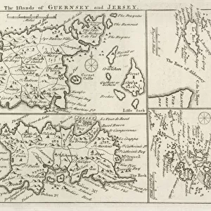
Photographic Print : Antique map, Channel Island, Jersey, Guernsey, Alderney 19th Century


![]()
Photo Prints from Fine Art Storehouse
Antique map, Channel Island, Jersey, Guernsey, Alderney 19th Century
Vintage engraving of a Antique map, Channel Island, Jersey, Guernsey, Alderney 19th Century with detail of St Helier
Unleash your creativity and transform your space into a visual masterpiece!
duncan1890
Media ID 15231367
© This content is subject to copyright
10"x8" (25x20cm) Photo Print
Discover the rich history of the Channel Islands with this stunning antique map print from the Media Storehouse range at Fine Art Storehouse. This vintage engraving, created in the 19th century by duncan1890, beautifully captures the detail of Jersey, Guernsey, and Alderley. The intricate depiction of St. Helier, the capital of Jersey, adds an extra layer of interest to this historical piece. Bring a touch of the past into your home or office with this authentic and captivating antique map print.
Printed on archival quality paper for unrivalled stable artwork permanence and brilliant colour reproduction with accurate colour rendition and smooth tones. Printed on professional 234gsm Fujifilm Crystal Archive DP II paper. 10x8 for landscape images, 8x10 for portrait images.
Our Photo Prints are in a large range of sizes and are printed on Archival Quality Paper for excellent colour reproduction and longevity. They are ideal for framing (our Framed Prints use these) at a reasonable cost. Alternatives include cheaper Poster Prints and higher quality Fine Art Paper, the choice of which is largely dependant on your budget.
Estimated Product Size is 20.3cm x 25.4cm (8" x 10")
These are individually made so all sizes are approximate
Artwork printed orientated as per the preview above, with portrait (vertical) orientation to match the source image.
FEATURES IN THESE COLLECTIONS
> Fine Art Storehouse
> Map
> Historical Maps
> Maps and Charts
> Related Images
EDITORS COMMENTS
This print takes us back in time to the 19th century, where we find ourselves immersed in the beauty and intricacy of an antique map showcasing the Channel Islands. The islands of Jersey, Guernsey, and Alderney are brought to life through this vintage engraving, capturing our attention with its remarkable detail. As we gaze upon this piece, our eyes are immediately drawn to St Helier, a focal point that stands out amidst the surrounding islands. The artist's skillful hand has meticulously crafted every line and curve on this map, allowing us to appreciate the artistry involved in creating such a historical document. The warm tones and aged texture of this print evoke a sense of nostalgia as we imagine what life was like during that era. It transports us to a time when exploration was at its peak and maps were essential tools for navigation. Whether you have a personal connection to these Channel Islands or simply admire their rich history, this print is sure to be a cherished addition to any collection. Its timeless appeal will captivate viewers from all walks of life while serving as a reminder of the importance of preserving our past for future generations.
MADE IN THE UK
Safe Shipping with 30 Day Money Back Guarantee
FREE PERSONALISATION*
We are proud to offer a range of customisation features including Personalised Captions, Color Filters and Picture Zoom Tools
SECURE PAYMENTS
We happily accept a wide range of payment options so you can pay for the things you need in the way that is most convenient for you
* Options may vary by product and licensing agreement. Zoomed Pictures can be adjusted in the Basket.