Photographic Print > Maps and Charts > Related Images
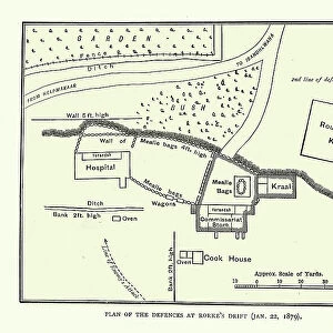
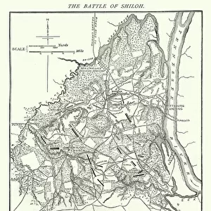
Photographic Print : Map of the area around Isandlwana, Anglo-Zulu War, 1879


![]()
Photo Prints from Fine Art Storehouse
Map of the area around Isandlwana, Anglo-Zulu War, 1879
Vintage engraving of Map of the area around Isandlwana, Anglo-Zulu War, 1879
Unleash your creativity and transform your space into a visual masterpiece!
duncan1890
Media ID 32086707
© of Duncan P Walker
Anglo Zulu War Battle Of Isandlwana
10"x8" (25x20cm) Photo Print
Step back in time with our captivating collection of vintage photographic prints. This exquisite engraving, 'Map of the area around Isandlwana, Anglo-Zulu War, 1879,' by duncan1890 from Fine Art Storehouse, offers a fascinating glimpse into history. Immerse yourself in the intricate details and relive this significant moment through this timeless piece of art.
Printed on archival quality paper for unrivalled stable artwork permanence and brilliant colour reproduction with accurate colour rendition and smooth tones. Printed on professional 234gsm Fujifilm Crystal Archive DP II paper. 10x8 for landscape images, 8x10 for portrait images.
Our Photo Prints are in a large range of sizes and are printed on Archival Quality Paper for excellent colour reproduction and longevity. They are ideal for framing (our Framed Prints use these) at a reasonable cost. Alternatives include cheaper Poster Prints and higher quality Fine Art Paper, the choice of which is largely dependant on your budget.
Estimated Product Size is 20.3cm x 25.4cm (8" x 10")
These are individually made so all sizes are approximate
Artwork printed orientated as per the preview above, with portrait (vertical) orientation to match the source image.
FEATURES IN THESE COLLECTIONS
> Fine Art Storehouse
> History
> Battles & Wars
> Historcal Battle Maps and Plans
> Fine Art Storehouse
> Map
> Historical Maps
> Historic
> Battles
> Related Images
> Maps and Charts
> Related Images
EDITORS COMMENTS
This vintage engraving transports us back to the tumultuous era of the Anglo-Zulu War in 1879. The intricate details of this map provide a fascinating glimpse into the area surrounding Isandlwana, where one of the most significant battles took place during this historic conflict. As we study this print, we can almost feel ourselves stepping onto that very terrain, immersing ourselves in the strategic importance and natural beauty of this region. The Map of the area around Isandlwana showcases both its geographical features and military significance. Every contour line and topographical element has been meticulously etched, revealing valleys, hills, rivers, and other landmarks that played a crucial role in shaping the outcome of battle. It is as if time stands still within these lines; they bear witness to the bravery and sacrifice exhibited by soldiers on both sides. Duncan1890's artistic prowess shines through in his masterful execution of this print. The attention to detail is awe-inspiring – from delicate shading techniques to precise labeling – all contributing to an immersive experience for any history enthusiast or art connoisseur alike. As we gaze upon this remarkable piece from Fine Art Storehouse, our minds wander back to a momentous chapter in history when two cultures clashed amidst breathtaking landscapes. This print serves as a poignant reminder not only of past conflicts but also as a testament to humanity's enduring fascination with preserving stories through art.
MADE IN THE UK
Safe Shipping with 30 Day Money Back Guarantee
FREE PERSONALISATION*
We are proud to offer a range of customisation features including Personalised Captions, Color Filters and Picture Zoom Tools
SECURE PAYMENTS
We happily accept a wide range of payment options so you can pay for the things you need in the way that is most convenient for you
* Options may vary by product and licensing agreement. Zoomed Pictures can be adjusted in the Basket.