Photographic Print > Fine Art Finder > Artists > Robert Morden
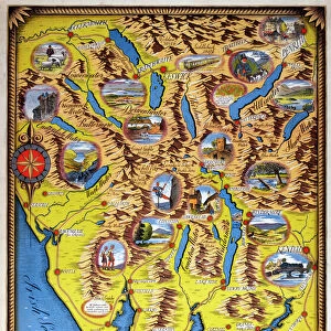
Photographic Print : Map of Cumberland, c. 1695 (engraving)
")

Please select a smaller print size for this image
![]()
Photo Prints from Fine Art Finder
Map of Cumberland, c. 1695 (engraving)
XJF448251 Map of Cumberland, c.1695 (engraving) by Morden, Robert (fl.1682-1703); Private Collection; English, out of copyright
Media ID 12883474
© www.bridgemanart.com
County Cumberland Cumbria Lake District North West
10"x8" (25x20cm) Photo Print
Discover the historical charm of yesteryears with our exquisite selection of Photographic Prints from Media Storehouse. This particular piece showcases an intricately detailed engraving, "Map of Cumberland, c.1695" by Robert Morden. With meticulous attention to detail, this print captures the essence of 17th-century cartography. A fascinating addition to your home or office, this out-of-copyright artwork from Bridgeman Art Library brings history to life, transporting you back in time. Order now and let the captivating details unfold before your eyes.
Printed on archival quality paper for unrivalled stable artwork permanence and brilliant colour reproduction with accurate colour rendition and smooth tones. Printed on professional 234gsm Fujifilm Crystal Archive DP II paper. 10x8 for landscape images, 8x10 for portrait images.
Our Photo Prints are in a large range of sizes and are printed on Archival Quality Paper for excellent colour reproduction and longevity. They are ideal for framing (our Framed Prints use these) at a reasonable cost. Alternatives include cheaper Poster Prints and higher quality Fine Art Paper, the choice of which is largely dependant on your budget.
Estimated Product Size is 25.4cm x 20.3cm (10" x 8")
These are individually made so all sizes are approximate
Artwork printed orientated as per the preview above, with landscape (horizontal) orientation to match the source image.
EDITORS COMMENTS
This engraving, titled "Map of Cumberland, c. 1695" takes us on a journey back in time to the picturesque landscapes of England's historic county. Created by the skilled cartographer Robert Morden during his flourishing years between 1682 and 1703, this print offers a fascinating glimpse into the past. The map showcases Cumberland, now known as Cumbria, located in the enchanting North West region of England. With its intricate details and precise markings, it provides an invaluable historical record of this beautiful area. From rolling hills to charming villages and towns nestled amidst lush greenery, every corner is meticulously depicted with artistic finesse. As we explore this ancient land through Morden's eyes, our imagination wanders to days long gone by - when horse-drawn carriages traversed winding roads and bustling marketplaces thrived with activity. The map also hints at Cumberland's close proximity to the renowned Lake District National Park – a haven for nature enthusiasts seeking solace amidst breathtaking scenery. Preserved within a private collection today but made accessible through Fine Art Finder's digital platform courtesy of www. bridgemanart. com; this remarkable piece invites us to appreciate both its aesthetic charm and historical significance. It serves as a reminder that art can be more than just visually pleasing; it can transport us across time and space while preserving our collective heritage for generations to come.
MADE IN THE UK
Safe Shipping with 30 Day Money Back Guarantee
FREE PERSONALISATION*
We are proud to offer a range of customisation features including Personalised Captions, Color Filters and Picture Zoom Tools
FREE COLORIZATION SERVICE
You can choose advanced AI Colorization for this picture at no extra charge!
SECURE PAYMENTS
We happily accept a wide range of payment options so you can pay for the things you need in the way that is most convenient for you
* Options may vary by product and licensing agreement. Zoomed Pictures can be adjusted in the Basket.