Photographic Print > Africa > South Africa > Maps
Photographic Print : Isotherms, South Africa and South East Australia (colour litho)
")

![]()
Photo Prints from Fine Art Finder
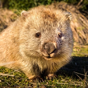
Isotherms, South Africa and South East Australia (colour litho)
6015852 Isotherms, South Africa and South East Australia (colour litho) by English School, (19th century); Private Collection; (add.info.: Isotherms, South Africa and South East Australia. Illustration for Atlas of Meteorology, Volume III of Bartholomews Physical Atlas, prepared by J G Bartholomew and A J Herbertson (The Royal Geographical Society, 1899). A set of maps that give a perspective of global weather at the end of the nineteenth century.); © Look and Learn
Media ID 23601424
© Look and Learn / Bridgeman Images
Atmospheric Change Cool Cooling Earth Forecasting Global Isotherms Meteorlogical Meteorological Meteorologists Temperature Warm Warming
10"x8" (25x20cm) Photo Print
Discover the captivating beauty of Isotherms, South Africa and South East Australia, as depicted in this stunning 19th century colour lithograph by the English School. This exquisite piece from Bridgeman Images' Media Storehouse range showcases the intricate detail and vibrant hues of the landscapes, making it a must-have addition to any fine art collection. Explore the rich history and natural wonders of these regions through the lens of this timeless masterpiece.
Printed on archival quality paper for unrivalled stable artwork permanence and brilliant colour reproduction with accurate colour rendition and smooth tones. Printed on professional 234gsm Fujifilm Crystal Archive DP II paper. 10x8 for landscape images, 8x10 for portrait images.
Our Photo Prints are in a large range of sizes and are printed on Archival Quality Paper for excellent colour reproduction and longevity. They are ideal for framing (our Framed Prints use these) at a reasonable cost. Alternatives include cheaper Poster Prints and higher quality Fine Art Paper, the choice of which is largely dependant on your budget.
Estimated Product Size is 25.4cm x 20.3cm (10" x 8")
These are individually made so all sizes are approximate
Artwork printed orientated as per the preview above, with landscape (horizontal) orientation to match the source image.
FEATURES IN THESE COLLECTIONS
> Fine Art Finder
> Artists
> English School
> Fine Art Finder
> Artists
> Percy F.S. (after) Spence
> Africa
> Related Images
> Africa
> South Africa
> Maps
> Africa
> South Africa
> Related Images
> Maps and Charts
> Early Maps
> Maps and Charts
> Related Images
> Maps and Charts
> World
> Oceania
> Australia
> Related Images
EDITORS COMMENTS
This print titled "Isotherms, South Africa and South East Australia" takes us back to the 19th century, offering a glimpse into the world of meteorology during that time. Created by an English School in the late 1800s, this colour lithograph was part of Bartholomews Physical Atlas, a significant contribution to scientific knowledge. The image showcases isotherms - lines connecting points with equal temperature - across South Africa and South East Australia. It serves as an illustration for Volume III of the Atlas of Meteorology, prepared by J G Bartholomew and A J Herbertson under The Royal Geographical Society in 1899. This set of maps provides valuable insights into global weather patterns at the end of the nineteenth century. As we explore this historical piece, it reminds us of how far meteorological science has come since then. From forecasting techniques to understanding climate change and atmospheric conditions, scientists have made tremendous progress over time. This artwork not only highlights their dedication but also emphasizes the importance of scientific methods in studying our planet's weather systems. With its warm colors representing different temperature ranges and intricate details depicting geographical features, this print transports us to a different era while reminding us that even centuries ago, people were fascinated by understanding Earth's climate dynamics. It stands as a testament to human curiosity about our surroundings and serves as a reminder that there is always more to learn about our ever-changing world.
MADE IN THE UK
Safe Shipping with 30 Day Money Back Guarantee
FREE PERSONALISATION*
We are proud to offer a range of customisation features including Personalised Captions, Color Filters and Picture Zoom Tools
SECURE PAYMENTS
We happily accept a wide range of payment options so you can pay for the things you need in the way that is most convenient for you
* Options may vary by product and licensing agreement. Zoomed Pictures can be adjusted in the Basket.