
Photographic Print > Europe > France > Maps
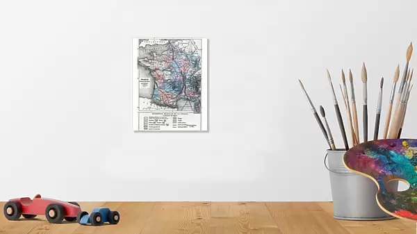
Photographic Print : Representation of a geographic map of France at the end of the 19th century with areas corresponding to diseases (scrofule, phtisia, malaria, goiter and cretinism, pellagre, moth)
")

![]()
Photo Prints from Fine Art Finder
Representation of a geographic map of France at the end of the 19th century with areas corresponding to diseases (scrofule, phtisia, malaria, goiter and cretinism, pellagre, moth)
ELD4948341 Representation of a geographic map of France at the end of the 19th century with areas corresponding to diseases (scrofule, phtisia, malaria, goiter and cretinism, pellagre, moth, cholera) Engraving from " La nature et l'homme" by Rengade 1881 Private collection by Demarle, Alphonse (1826-1896); (add.info.: Representation of a geographic map of France at the end of the 19th century with areas corresponding to diseases (scrofule, phtisia, malaria, goiter and cretinism, pellagre, moth, cholera) Engraving from " La nature et l'homme" by Rengade 1881 Private collection); Photo © The Holbarn Archive
Media ID 31932943
© The Holbarn Archive / Bridgeman Images
Carte Geographique Disease France Francais Francaise Francaises Geographie Malade Maladie Medecine Sante Geographical Map Homme Isadora
10"x8" (25x20cm) Photo Print
Discover the fascinating history of public health in France with our exclusive Media Storehouse Photographic Prints. This captivating image from Bridgeman Images, ELD4948341, showcases a geographic map of France at the end of the 19th century. Each region is marked with the corresponding disease that once plagued its inhabitants, including scrofule, phtisia, malaria, goiter and cretinism, pellagre, and moth. This unique and informative print is perfect for adding a touch of historical intrigue to any room, and is sure to spark conversation among guests. Bring a piece of the past into your home or office with our high-quality, museum-grade prints.
Printed on archival quality paper for unrivalled stable artwork permanence and brilliant colour reproduction with accurate colour rendition and smooth tones. Printed on professional 234gsm Fujifilm Crystal Archive DP II paper. 10x8 for landscape images, 8x10 for portrait images.
Our Photo Prints are in a large range of sizes and are printed on Archival Quality Paper for excellent colour reproduction and longevity. They are ideal for framing (our Framed Prints use these) at a reasonable cost. Alternatives include cheaper Poster Prints and higher quality Fine Art Paper, the choice of which is largely dependant on your budget.
Estimated Image Size (if not cropped) is 17.7cm x 25.4cm (7" x 10")
Estimated Product Size is 20.3cm x 25.4cm (8" x 10")
These are individually made so all sizes are approximate
Artwork printed orientated as per the preview above, with portrait (vertical) orientation to match the source image.
FEATURES IN THESE COLLECTIONS
> Fine Art Finder
> Artists
> Alphonse Demarle
> Maps and Charts
> Early Maps
> Maps and Charts
> Related Images
EDITORS COMMENTS
This print showcases a representation of a geographic map of France at the end of the 19th century, highlighting areas corresponding to various diseases. Created by Alphonse Demarle and featured in "La nature et l'homme" by Rengade in 1881, this engraving offers a unique glimpse into the health landscape of that era. The intricate details on the map reveal regions afflicted with diseases such as scrofula, phthisis, malaria, goiter and cretinism, pellagra, moth infestation, and cholera. Each area is meticulously marked to indicate the prevalence or impact of these ailments within specific locations across France. As we delve into this historical artifact, it becomes evident that understanding disease patterns was crucial for medical professionals during this time. The map serves as both an informative tool and a testament to the advancements made in healthcare throughout history. Through its depiction of human suffering caused by these illnesses, one can't help but appreciate how far we have come in terms of medical knowledge and treatment options. This image reminds us not only of our progress but also highlights the importance of continued research and innovation in combating diseases that once plagued societies. Preserved within private collections like The Holbarn Archive, this photograph allows us to reflect on our past while inspiring hope for healthier futures. It serves as a reminder that our collective efforts towards better health are essential for building resilient communities worldwide.
MADE IN THE UK
Safe Shipping with 30 Day Money Back Guarantee
FREE PERSONALISATION*
We are proud to offer a range of customisation features including Personalised Captions, Color Filters and Picture Zoom Tools
SECURE PAYMENTS
We happily accept a wide range of payment options so you can pay for the things you need in the way that is most convenient for you
* Options may vary by product and licensing agreement. Zoomed Pictures can be adjusted in the Basket.


