Photo Mug > Europe > United Kingdom > England > Sussex > Balcombe
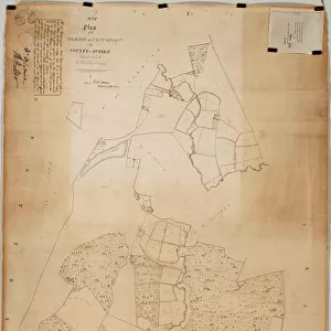
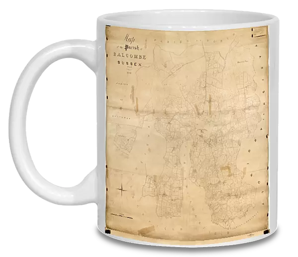
Photo Mug : Balcombe Tithe Map, 1842


![]()
Home Decor from West Sussex County Council
Balcombe Tithe Map, 1842
By H. Walter. 20 in. to 1 m. Original Map size 79in. × 77in.
Tithe Award Map Collection
West Sussex Record Office Ref No: TD/E24
West Sussex County Council Record Office contains a fascinating history of the county of West Sussex, England
Media ID 7915648
© West Sussex County Council - All Rights Reserved
1840s Historical Mapping Parish
Photo Mug
"Bring history to your morning routine with our Media Storehouse Photo Mugs. Featuring an intriguing image from the West Sussex Record Office, this mug showcases the Balcombe Tithe Map from 1842. This detailed map, originally measuring 79 inches by 77 inches, is now beautifully preserved on your mug. Travel back in time with each sip of your favorite beverage, making every moment a journey through history."
A personalised photo mug blends sentimentality with functionality, making an ideal gift for cherished loved ones, close friends, or valued colleagues. Preview may show both sides of the same mug.
Elevate your coffee or tea experience with our premium white ceramic mug. Its wide, comfortable handle makes drinking easy, and you can rely on it to be both microwave and dishwasher safe. Sold in single units, preview may show both sides of the same mug so you can see how the picture wraps around.
Mug Size is 9.5cm high x 8cm diameter (3.7" x 3.1")
These are individually made so all sizes are approximate
FEATURES IN THESE COLLECTIONS
> Europe
> United Kingdom
> England
> Sussex
> Balcombe
> Europe
> United Kingdom
> England
> Sussex
> Related Images
> Europe
> United Kingdom
> England
> West Sussex
> Related Images
> Maps and Charts
> Early Maps
> Maps and Charts
> Related Images
> West Sussex County Council
> West Sussex Record Office
> Tithe Award Maps, 1808-1859
EDITORS COMMENTS
This print showcases the Balcombe Tithe Map from 1842, a remarkable piece of historical mapping created by H. Walter. The map's original size measures an impressive 79 inches by 77 inches, and this high-quality reproduction allows us to delve into the intricate details of this significant document. Part of the esteemed Tithe Award Map Collection housed at the West Sussex Record Office, this particular map holds immense value for researchers and history enthusiasts alike. It offers a glimpse into the past, providing insights into land ownership, boundaries, and land use within the parish during the 1840s. The meticulous craftsmanship evident in every inch of this map is truly awe-inspiring. Its vibrant colors and precise markings transport us back in time to an era when maps were meticulously hand-drawn with utmost care and attention to detail. As we explore this fascinating artifact from West Sussex County Council's archives, it is important to note that its significance lies solely in its historical context rather than any commercial use. This photograph serves as a testament to our commitment to preserving our rich heritage for future generations. Whether you are studying local history or simply captivated by cartography's beauty, immerse yourself in the splendor of Balcombe Tithe Map - a window into a bygone era that continues to fascinate and inspire today.
MADE IN THE UK
Safe Shipping with 30 Day Money Back Guarantee
FREE PERSONALISATION*
We are proud to offer a range of customisation features including Personalised Captions, Color Filters and Picture Zoom Tools
SECURE PAYMENTS
We happily accept a wide range of payment options so you can pay for the things you need in the way that is most convenient for you
* Options may vary by product and licensing agreement. Zoomed Pictures can be adjusted in the Basket.