Photo Mug > Europe > United Kingdom > Wales > Maps
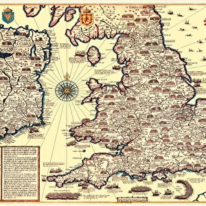
Photo Mug : Map of England and Wales as it appeared after the Accession of The House of Tuder


![]()
Home Decor from MapSeeker
Map of England and Wales as it appeared after the Accession of The House of Tuder
BHISM003
Welcome to the Mapseeker Image library and enter an historic gateway to one of the largest on-line collections of Historic Maps, Nostalgic Views, Vista's and Panorama's from a World gone by.
Media ID 20348260
Photo Mug
Bring a piece of history to your morning routine with the Media Storehouse Photo Mug featuring a captivating Map of England and Wales as it appeared after the Accession of The House of Tudor from MapSeeker. Each mug in our range is expertly printed with high-quality images, ensuring your custom map design is vibrant and clear. Perfect for history enthusiasts or as a thoughtful gift, this mug not only keeps your beverage warm but also adds a touch of intrigue to your daily life. Embrace the rich tapestry of history with every sip.
A personalised photo mug blends sentimentality with functionality, making an ideal gift for cherished loved ones, close friends, or valued colleagues. Preview may show both sides of the same mug.
Elevate your coffee or tea experience with our premium white ceramic mug. Its wide, comfortable handle makes drinking easy, and you can rely on it to be both microwave and dishwasher safe. Sold in single units, preview may show both sides of the same mug so you can see how the picture wraps around.
Mug Size is 9.5cm high x 8cm diameter (3.7" x 3.1")
These are individually made so all sizes are approximate
FEATURES IN THESE COLLECTIONS
> MapSeeker
> Maps from the British Isles
> England with Wales PORTFOLIO
> Europe
> United Kingdom
> England
> Maps
> Europe
> United Kingdom
> Wales
> Maps
> Europe
> United Kingdom
> Wales
> Posters
> Europe
> United Kingdom
> Wales
> Related Images
> Maps and Charts
> Related Images
> Maps and Charts
> Wales
EDITORS COMMENTS
This print showcases a historical treasure, the "Map of England and Wales as it appeared after the Accession of The House of Tudor". A true gem for history enthusiasts and map aficionados alike, this exquisite piece from MapSeeker takes us on a journey back in time to the era when the Tudor dynasty reigned supreme. The map itself is an intricate work of art, meticulously crafted with remarkable attention to detail. It beautifully depicts the political boundaries and geographical features that defined England and Wales during this significant period. From rolling hills to winding rivers, every contour is delicately etched onto this vintage masterpiece. As we gaze upon this stunning print, our minds wander through centuries past. We envision bustling towns and cities brimming with life, grand castles standing proudly amidst lush landscapes, and mighty rivers serving as vital arteries connecting different regions. Beyond its aesthetic appeal lies a wealth of historical knowledge waiting to be explored. This map offers valuable insights into how power shifted across these lands under the reigns of Henry VII, Henry VIII, Edward VI, Mary I (also known as Bloody Mary), and Elizabeth I – collectively known as the House of Tudor. Whether you are an avid historian or simply captivated by beautiful cartography, this print serves as both a visual delight and an educational tool. It invites us to delve deeper into England's rich heritage while appreciating the artistic brilliance behind its creation.
MADE IN THE UK
Safe Shipping with 30 Day Money Back Guarantee
FREE PERSONALISATION*
We are proud to offer a range of customisation features including Personalised Captions, Color Filters and Picture Zoom Tools
SECURE PAYMENTS
We happily accept a wide range of payment options so you can pay for the things you need in the way that is most convenient for you
* Options may vary by product and licensing agreement. Zoomed Pictures can be adjusted in the Basket.