Photo Mug > Arts > Artists > T > John Tallis
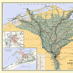
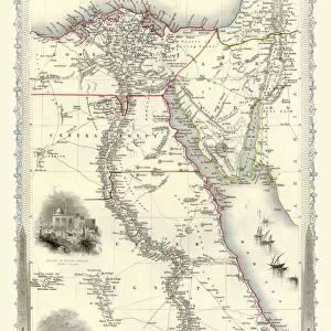
Photo Mug : Old Map of Egypt and Arabia Petraea 1851 by John Tallis


![]()
Home Decor from MapSeeker
Old Map of Egypt and Arabia Petraea 1851 by John Tallis
A fine facimile artworked from an antique original map of Egypt and Arabia Petraea, issued as part of the 1851 edition of John Tallis and Companys " The Illustrated Atlas and Modern History of the World"
Welcome to the Mapseeker Image library and enter an historic gateway to one of the largest on-line collections of Historic Maps, Nostalgic Views, Vista's and Panorama's from a World gone by.
Media ID 20347664
© Mapseeker Publishing Ltd
John Tallis John Tallis Map Tallis Map
Photo Mug
Step back in time with our Media Storehouse Photo Mug featuring an exquisite reproduction of the Old Map of Egypt and Arabia Petraea, 1851 by John Tallis and John Rapkin from MapSeeker. This fine facsimile artwork, taken from an antique original map, brings the rich history of Egypt and Arabia Petraea to life. Each mug holds your favorite beverage in high style, making it an ideal gift for history enthusiasts, map collectors, or anyone who appreciates the beauty of vintage cartography. Sip and savor the past with every drink.
A personalised photo mug blends sentimentality with functionality, making an ideal gift for cherished loved ones, close friends, or valued colleagues. Preview may show both sides of the same mug.
Elevate your coffee or tea experience with our premium white ceramic mug. Its wide, comfortable handle makes drinking easy, and you can rely on it to be both microwave and dishwasher safe. Sold in single units, preview may show both sides of the same mug so you can see how the picture wraps around.
Mug Size is 9.5cm high x 8cm diameter (3.7" x 3.1")
These are individually made so all sizes are approximate
FEATURES IN THESE COLLECTIONS
> MapSeeker
> Maps of Asia and Middle East
> Maps of the Middle East and East Indies
> Africa
> Egypt
> Related Images
> Arts
> Artists
> T
> John Tallis
> Maps and Charts
> Related Images
> Maps and Charts
> World
EDITORS COMMENTS
This print showcases the "Old Map of Egypt and Arabia Petraea 1851" by John Tallis, a renowned cartographer of his time. This fine facsimile artwork is meticulously reproduced from an antique original map, which was originally issued as part of the 1851 edition of John Tallis and Company's "The Illustrated Atlas and Modern History of the World". Transporting us back in time, this map offers a glimpse into the rich history and geography of Egypt and Arabia Petraea during the mid-19th century. With intricate details and exquisite craftsmanship, it captures both the artistry and accuracy that made Tallis maps highly sought after. As we explore this old map, we can marvel at its depiction of ancient cities like Cairo, Alexandria, Luxor, and Thebes. It also highlights significant landmarks such as the Nile River winding through lush landscapes dotted with pyramids. The borders are adorned with ornate illustrations showcasing local flora, fauna, historical figures, and cultural symbols. John Tallis collaborated with talented engraver John Rapkin to create this masterpiece that not only serves as a geographical reference but also evokes a sense of wonderment for those who appreciate cartographic artistry. Whether you are an avid historian or simply captivated by vintage maps, this print transports you to another era while celebrating the timeless beauty found within these historic documents.
MADE IN THE UK
Safe Shipping with 30 Day Money Back Guarantee
FREE PERSONALISATION*
We are proud to offer a range of customisation features including Personalised Captions, Color Filters and Picture Zoom Tools
SECURE PAYMENTS
We happily accept a wide range of payment options so you can pay for the things you need in the way that is most convenient for you
* Options may vary by product and licensing agreement. Zoomed Pictures can be adjusted in the Basket.