Photo Mug > Europe > France > Canton > Landes
Photo Mug : Childrens Political World Map


![]()
Home Decor from Map Marketing
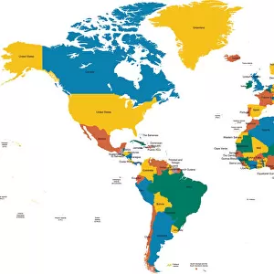
Childrens Political World Map
A Political map of the World designed for school children. Based on the Van Der Grinten projection, the World map displays international political boundaries, including ones which are disputed. The map clearly marks each country in a different colour and shows major cities in five different population bands, with capital cities clearly marked in red. The corners of the map feature inserts showing the layout of the solar system and phases of the moon along with graphics ranking the four largest countries by population and land mass in comparison to the British Isles. Lines of latitude (parallels) and longitude (meridians) are marked
Media ID 19950545
© Map Marketing Ltd
Photo Mug
A personalised photo mug blends sentimentality with functionality, making an ideal gift for cherished loved ones, close friends, or valued colleagues. Preview may show both sides of the same mug.
Elevate your coffee or tea experience with our premium white ceramic mug. Its wide, comfortable handle makes drinking easy, and you can rely on it to be both microwave and dishwasher safe. Sold in single units, preview may show both sides of the same mug so you can see how the picture wraps around.
Mug Size is 8cm high x 9.5cm diameter (3.1" x 3.7")
These are individually made so all sizes are approximate
FEATURES IN THESE COLLECTIONS
> Europe
> France
> Canton
> Landes
> Maps and Charts
> Popular Maps
> Maps and Charts
> Related Images
> Maps and Charts
> World
MADE IN THE UK
Safe Shipping with 30 Day Money Back Guarantee
FREE PERSONALISATION*
We are proud to offer a range of customisation features including Personalised Captions, Color Filters and Picture Zoom Tools
SECURE PAYMENTS
We happily accept a wide range of payment options so you can pay for the things you need in the way that is most convenient for you
* Options may vary by product and licensing agreement. Zoomed Pictures can be adjusted in the Basket.