Photo Mug > Arts > Artists > V > Claes Jansz Visscher
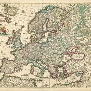
Photo Mug : Map Tabula exactissima Regnorum Sueciae et Norvegiae


![]()
Home Decor from Liszt Collection
Map Tabula exactissima Regnorum Sueciae et Norvegiae
Map, Tabula exactissima Regnorum Sueciae et Norvegiae, nec non Maris Universi Orientalis, terrarumq. adjacentium, Claes Jansz. Visscher (1586/1587-1652), Copperplate print
Liszt Collection of nineteenth-century engravings and images to browse and enjoy
Media ID 19585207
© Artokoloro
Copperplate Print Visscher Claes Jansz
Photo Mug
Add a touch of history to your daily routine with our Media Storehouse Photo Mugs. Featuring the intricately detailed and captivating Tabula exactissima Regnorum Sueciae et Norvegiae map from the Liszt Collection, these mugs showcase the rich cartography of Claes Jansz. Visscher's copperplate print. Each mug holds your favorite beverage while transporting you back in time, making every sip an adventure. Perfect for history enthusiasts, collectors, or as a unique gift, our Photo Mugs bring the beauty of the past right to your table.
A personalised photo mug blends sentimentality with functionality, making an ideal gift for cherished loved ones, close friends, or valued colleagues. Preview may show both sides of the same mug.
Elevate your coffee or tea experience with our premium white ceramic mug. Its wide, comfortable handle makes drinking easy, and you can rely on it to be both microwave and dishwasher safe. Sold in single units, preview may show both sides of the same mug so you can see how the picture wraps around.
Mug Size is 8cm high x 9.5cm diameter (3.1" x 3.7")
These are individually made so all sizes are approximate
FEATURES IN THESE COLLECTIONS
> Animals
> Mammals
> Cricetidae
> Orientalis
> Arts
> Artists
> V
> Claes Jansz Visscher
> Maps and Charts
> Related Images
EDITORS COMMENTS
This print showcases the remarkable "Map Tabula exactissima Regnorum Sueciae et Norvegiae" by Claes Jansz. Visscher, a renowned Dutch cartographer from the 17th century. The intricacy and precision of this copperplate print are truly awe-inspiring. Visscher's expertise in mapmaking is evident in every detail of this masterpiece. With utmost accuracy, he depicts the kingdoms of Sweden and Norway, as well as the vast Eastern Sea and neighboring lands. This map not only serves as a navigational tool but also offers a glimpse into the geographical knowledge of that era. The craftsmanship exhibited in this print is exceptional. Each line and contour on the copperplate has been meticulously engraved to ensure clarity and readability. The delicate shading techniques employed bring life to mountains, rivers, forests, and coastlines alike. As we delve into this historical artifact through our lens, we can't help but marvel at Visscher's dedication to capturing geographical truthfulness during a time when exploration was still unfolding. This work stands as a testament to his passion for cartography and his commitment to presenting accurate representations of these Nordic territories. Whether you're an avid collector or simply appreciate artistry with historical significance, this print allows you to own a piece of history while immersing yourself in Visscher's world-renowned talent for mapping excellence.
MADE IN THE UK
Safe Shipping with 30 Day Money Back Guarantee
FREE PERSONALISATION*
We are proud to offer a range of customisation features including Personalised Captions, Color Filters and Picture Zoom Tools
SECURE PAYMENTS
We happily accept a wide range of payment options so you can pay for the things you need in the way that is most convenient for you
* Options may vary by product and licensing agreement. Zoomed Pictures can be adjusted in the Basket.