Photo Mug > Arts > Minimalist artwork > Monochrome artwork > Fine art
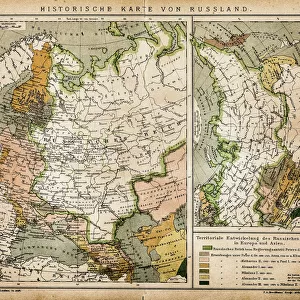
Photo Mug : Map of the area where the Crimean War was fought in the 1850s, (c1920). Artist: Walter Hutchinson
. Artist: Walter Hutchinson")
. Artist: Walter Hutchinson")

![]()
Home Decor from Heritage Images
Map of the area where the Crimean War was fought in the 1850s, (c1920). Artist: Walter Hutchinson
Map of the area where the Crimean War was fought in the 1850s, (c1920). The plan shows the relative positions of the battlefields of Crimea. Illustration from Story of the British Nation, Volume IV, by Walter Hutchinson, (London, c1920s)
Heritage Images features heritage image collections
Media ID 14933898
© The Print Collector / Heritage-Images
Balaclava Balaklava Black Sea Crimea Crimean War 1853 1856 Hutchinson Inkerman Krym Sebastopol Sevastopol Ukraine Walter Walter Hutchinson Yalta
Photo Mug
Step back in time with our Media Storehouse Photo Mug, featuring an intriguing historical map of the Crimean War battlefields from the early 1900s. This vintage map, created by renowned artist Walter Hutchinson, showcases the key locations of the Crimean War, fought in the 1850s. Bring history to life with every sip from this beautifully designed mug, perfect for history enthusiasts or as a unique gift. Image courtesy of Heritage Images.
A personalised photo mug blends sentimentality with functionality, making an ideal gift for cherished loved ones, close friends, or valued colleagues. Preview may show both sides of the same mug.
Elevate your coffee or tea experience with our premium white ceramic mug. Its wide, comfortable handle makes drinking easy, and you can rely on it to be both microwave and dishwasher safe. Sold in single units, preview may show both sides of the same mug so you can see how the picture wraps around.
Mug Size is 8cm high x 9.5cm diameter (3.1" x 3.7")
These are individually made so all sizes are approximate
FEATURES IN THESE COLLECTIONS
> Arts
> Minimalist artwork
> Monochrome artwork
> Fine art
> Arts
> Minimalist artwork
> Monochrome artwork
> Monochrome paintings
> Europe
> Ukraine
> Related Images
> Maps and Charts
> Related Images
> Popular Themes
> Balaclava, Crimea
EDITORS COMMENTS
This print, created by Walter Hutchinson in the 1920s, showcases a detailed map of the area where the Crimean War was fought in the 1850s. The artist's meticulous attention to geographical features allows viewers to gain a deeper understanding of this significant historical event. The map highlights various battlefields across Crimea, including Balaclava, Inkerman, and Sevastopol. These locations played crucial roles during the war and are marked with precision on this monochrome illustration. As we observe this piece, we can almost envision Victorian-era soldiers maneuvering through these strategic points. The print not only serves as an educational tool but also evokes a sense of curiosity about the geography of Ukraine's Crimean Peninsula. With Yalta and Sebastopol prominently featured on the map, it offers insight into how these cities were situated within their surroundings during that time period. Walter Hutchinson's expertise shines through in his ability to capture both historical accuracy and artistic beauty within this print. The intricate details invite us to explore every corner of this visual representation while contemplating the significance of each battlefield. As admirers delve into this remarkable artwork from Heritage Images' collection, they are transported back to one of history's most notable conflicts -the Crimean War- gaining a newfound appreciation for its impact on both local geography and global politics.
MADE IN THE UK
Safe Shipping with 30 Day Money Back Guarantee
FREE PERSONALISATION*
We are proud to offer a range of customisation features including Personalised Captions, Color Filters and Picture Zoom Tools
SECURE PAYMENTS
We happily accept a wide range of payment options so you can pay for the things you need in the way that is most convenient for you
* Options may vary by product and licensing agreement. Zoomed Pictures can be adjusted in the Basket.