Photo Mug > Europe > Austria > Maps
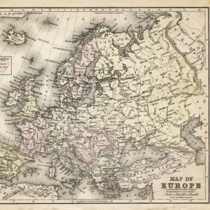
Photo Mug : Map of Europe 1889


![]()
Home Decor from Fine Art Storehouse
Map of Europe 1889
Indiana Educational Series The Complete Geography - Indianapolis 1889
Unleash your creativity and transform your space into a visual masterpiece!
THEPALMER
Media ID 14756326
© This content is subject to copyright
Austria Denmark Norway Portugal Russia Sweden
Photo Mug
Add a touch of history to your daily routine with our Media Storehouse Photo Mug featuring the captivating Map of Europe 1889 by THEPALMER from the Indianapolis 1889 Indiana Educational Series The Complete Geography. This vintage map transports you back in time, making your coffee or tea breaks an educational and enjoyable experience. Each mug is expertly printed with high-quality images to ensure vibrant colors and long-lasting durability. Perfect for history enthusiasts, travelers, or anyone who appreciates the beauty of old maps. Embrace the past, one sip at a time.
A personalised photo mug blends sentimentality with functionality, making an ideal gift for cherished loved ones, close friends, or valued colleagues. Preview may show both sides of the same mug.
Elevate your coffee or tea experience with our premium white ceramic mug. Its wide, comfortable handle makes drinking easy, and you can rely on it to be both microwave and dishwasher safe. Sold in single units, preview may show both sides of the same mug so you can see how the picture wraps around.
Mug Size is 8cm high x 9.5cm diameter (3.1" x 3.7")
These are individually made so all sizes are approximate
FEATURES IN THESE COLLECTIONS
> Fine Art Storehouse
> Map
> Denmark Maps
> Fine Art Storehouse
> Map
> Historical Maps
> Fine Art Storehouse
> Map
> Italian Maps
> Europe
> Austria
> Related Images
> Europe
> Denmark
> Related Images
> Europe
> Germany
> Related Images
EDITORS COMMENTS
This print titled "Map of Europe 1889" takes us on a journey back in time to the late 19th century. A part of the Indiana Educational Series, this vintage map showcases the intricate details and artistic craftsmanship that were characteristic of cartography during that era. The map, originating from Indianapolis in 1889, provides a fascinating glimpse into how Europeans perceived their continent over a century ago. With its rich color palette and meticulous depiction of geographical boundaries, this print offers an immersive experience for history enthusiasts and geography lovers alike. From Portugal to Russia, it encompasses all major European countries such as Austria, Denmark, France, Germany, Italy, Norway, Spain, Sweden - each marked with precision and accuracy. The fine art quality of this photograph allows viewers to appreciate every minute detail on display. The aged texture adds depth and character to the image while preserving its historical significance. Whether displayed in a classroom or as an elegant addition to your home decor collection, "Map of Europe 1889" by THEPALMER is sure to spark conversations about our ever-evolving world. As we gaze upon this remarkable piece from Fine Art Storehouse's collection without considering commercial use but rather appreciating it purely for its aesthetic value - we are transported back in time; reminded of the vastness and diversity that has shaped our beloved continent throughout centuries past.
MADE IN THE UK
Safe Shipping with 30 Day Money Back Guarantee
FREE PERSONALISATION*
We are proud to offer a range of customisation features including Personalised Captions, Color Filters and Picture Zoom Tools
SECURE PAYMENTS
We happily accept a wide range of payment options so you can pay for the things you need in the way that is most convenient for you
* Options may vary by product and licensing agreement. Zoomed Pictures can be adjusted in the Basket.