Photo Mug > Europe > Austria > Maps
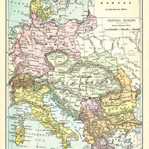
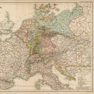
Photo Mug : Map of central Europe 1889


![]()
Home Decor from Fine Art Storehouse
Map of central Europe 1889
Indiana Educational Series The Complete Geography - Indianapolis 1889
Unleash your creativity and transform your space into a visual masterpiece!
THEPALMER
Media ID 14756322
© This content is subject to copyright
Austria Denmark Norway Portugal Russia Sweden
Photo Mug
"Add a touch of history to your daily routine with our Media Storehouse Photo Mugs. Featuring an exquisite image of "Map of Central Europe 1889" by THEPALMER from the Indianapolis 1889 Indiana Educational Series The Complete Geography, these mugs are not just functional but also a great conversation starter. Each mug is printed with high-quality, vibrant colors that bring the intricate details of the map to life. Perfect for history enthusiasts, travelers, or anyone who appreciates the beauty of vintage maps, these mugs are a unique and thoughtful gift. Embrace the past with a sip of your favorite beverage from one of our Media Storehouse Photo Mugs."
A personalised photo mug blends sentimentality with functionality, making an ideal gift for cherished loved ones, close friends, or valued colleagues. Preview may show both sides of the same mug.
Elevate your coffee or tea experience with our premium white ceramic mug. Its wide, comfortable handle makes drinking easy, and you can rely on it to be both microwave and dishwasher safe. Sold in single units, preview may show both sides of the same mug so you can see how the picture wraps around.
Mug Size is 8cm high x 9.5cm diameter (3.1" x 3.7")
These are individually made so all sizes are approximate
FEATURES IN THESE COLLECTIONS
> Fine Art Storehouse
> Map
> Denmark Maps
> Fine Art Storehouse
> Map
> Historical Maps
> Fine Art Storehouse
> Map
> Italian Maps
> Europe
> Austria
> Related Images
> Europe
> Denmark
> Related Images
> Europe
> Germany
> Related Images
EDITORS COMMENTS
This print titled "Map of Central Europe 1889" takes us on a journey back in time to the late 19th century. The image showcases an authentic reproduction of a map from the Indiana Educational Series, specifically "The Complete Geography - Indianapolis 1889". With intricate details and vibrant colors, this piece offers a glimpse into the geographical landscape of central Europe during that era. As we delve into the composition, our eyes are immediately drawn to Portugal, Austria, Denmark, France, Germany, Italy, Norway, Russia, Spain and Sweden. Each country is meticulously outlined with delicate precision and labeled with elegant typography. This historical artifact not only serves as a visual representation of the region's boundaries but also provides valuable insights into political divisions and territorial claims at that time. "The Map of Central Europe 1889" by THEPALMER transports us to an age where cartography was both artistry and science. It invites us to appreciate how knowledge was disseminated through beautifully crafted maps like these. Whether displayed in a classroom or cherished within one's personal collection, this print evokes nostalgia for an era when exploration and discovery were paramount. With its rich historical significance and meticulous attention to detail captured by Fine Art Storehouse photographers' expertise; this artwork becomes more than just a decorative piece—it becomes a gateway to understanding our past while appreciating the beauty found within educational resources such as maps.
MADE IN THE UK
Safe Shipping with 30 Day Money Back Guarantee
FREE PERSONALISATION*
We are proud to offer a range of customisation features including Personalised Captions, Color Filters and Picture Zoom Tools
SECURE PAYMENTS
We happily accept a wide range of payment options so you can pay for the things you need in the way that is most convenient for you
* Options may vary by product and licensing agreement. Zoomed Pictures can be adjusted in the Basket.