Photo Mug > Europe > United Kingdom > Scotland > Maps
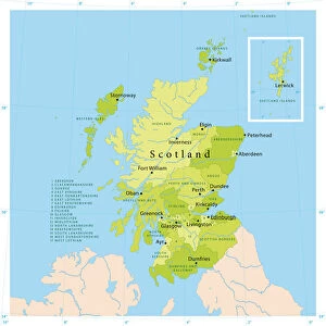
Photo Mug : Map of Scotland 1889


![]()
Home Decor from Fine Art Storehouse
Map of Scotland 1889
Comprehensive Geography by James Monteith - American Book Company 1882, 1889
Unleash your creativity and transform your space into a visual masterpiece!
THEPALMER
Media ID 18357297
Photo Mug
Introducing the Media Storehouse Photo Mug featuring the captivating "Map of Scotland 1889" by THEPALMER from our Fine Art Storehouse collection. This exquisite map, originally published in "Comprehensive Geography" by James Monteith in 1882 and 1889, is now transformed into a functional and stylish mug. Perfect for tea or coffee, this mug is not only an excellent conversation starter but also a beautiful addition to your daily routine. Immerse yourself in the intricate details of Scotland's historic geography as you savor your favorite beverage. Bring a piece of the past into your present with this unique and thoughtful gift.
A personalised photo mug blends sentimentality with functionality, making an ideal gift for cherished loved ones, close friends, or valued colleagues. Preview may show both sides of the same mug.
Elevate your coffee or tea experience with our premium white ceramic mug. Its wide, comfortable handle makes drinking easy, and you can rely on it to be both microwave and dishwasher safe. Sold in single units, preview may show both sides of the same mug so you can see how the picture wraps around.
Mug Size is 9.5cm high x 8cm diameter (3.7" x 3.1")
These are individually made so all sizes are approximate
FEATURES IN THESE COLLECTIONS
> Fine Art Storehouse
> Map
> Historical Maps
> Europe
> United Kingdom
> Scotland
> Maps
> Europe
> United Kingdom
> Scotland
> Posters
> Europe
> United Kingdom
> Scotland
> Related Images
> Maps and Charts
> Related Images
EDITORS COMMENTS
This print showcases a historical gem, the "Map of Scotland 1889" taken from James Monteith's renowned book "Comprehensive Geography". Published by the American Book Company in both 1882 and 1889, this map is a testament to the timeless allure of cartography. The intricate details etched on this vintage piece transport us back to an era when exploration and discovery were at their peak. The fine craftsmanship evident in every line and curve invites us to embark on a visual journey through Scotland's rich geography. From its majestic highlands adorned with rugged peaks, serene lochs, and winding rivers, to its picturesque lowlands dotted with charming towns and bustling cities - this map encapsulates the essence of Scotland. As we delve into this snapshot of history captured by THEPALMER for Fine Art Storehouse, we are reminded of how maps have always been more than just navigational tools; they are windows into our past. This particular print allows us to appreciate not only the beauty but also the significance of cartographic artistry as it was practiced over a century ago. Whether you're an avid historian or simply captivated by Scotland's enchanting landscapes, let this exquisite print take you on a mesmerizing voyage through time as you explore one of Europe's most captivating countries.
MADE IN THE UK
Safe Shipping with 30 Day Money Back Guarantee
FREE PERSONALISATION*
We are proud to offer a range of customisation features including Personalised Captions, Color Filters and Picture Zoom Tools
SECURE PAYMENTS
We happily accept a wide range of payment options so you can pay for the things you need in the way that is most convenient for you
* Options may vary by product and licensing agreement. Zoomed Pictures can be adjusted in the Basket.