Photo Mug > North America > United States of America > New York > New York > Maps
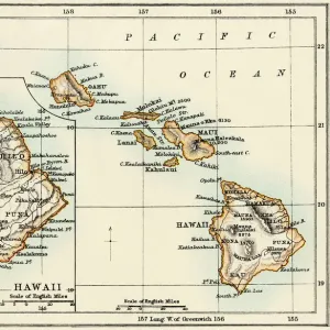
Photo Mug : Map of Hawaiian islands 1883


![]()
Home Decor from Fine Art Storehouse
Map of Hawaiian islands 1883
Encyclopedia Britannica 9th Edition New York Samuel L. Hall 1883 Vol XI
Unleash your creativity and transform your space into a visual masterpiece!
THEPALMER
Media ID 14756800
© This content is subject to copyright
Photo Mug
"Bring a piece of historical paradise to your daily routine with our Media Storehouse Photo Mug featuring the iconic "Map of Hawaiian Islands 1883" by THEPALMER from Fine Art Storehouse. This exquisite design, taken from the Encyclopedia Britannica 9th Edition New York Samuel L. Hall 1883 Vol XI, is sure to transport you to the beautiful shores of the Hawaiian Islands with every sip. Perfect for coffee, tea, or hot chocolate, our high-quality mugs showcase vibrant, fade-resistant prints and a comfortable, ergonomic design. Make your mug collection a work of art with this unique and captivating addition."
A personalised photo mug blends sentimentality with functionality, making an ideal gift for cherished loved ones, close friends, or valued colleagues. Preview may show both sides of the same mug.
Elevate your coffee or tea experience with our premium white ceramic mug. Its wide, comfortable handle makes drinking easy, and you can rely on it to be both microwave and dishwasher safe. Sold in single units, preview may show both sides of the same mug so you can see how the picture wraps around.
Mug Size is 8cm high x 9.5cm diameter (3.1" x 3.7")
These are individually made so all sizes are approximate
FEATURES IN THESE COLLECTIONS
> Fine Art Storehouse
> Map
> Historical Maps
> Arts
> Artists
> O
> Oceanic Oceanic
> Maps and Charts
> Related Images
> North America
> United States of America
> New York
> New York
> Maps
> North America
> United States of America
> New York
> Related Images
EDITORS COMMENTS
This print showcases a fascinating piece of history - the "Map of Hawaiian Islands 1883" from the Encyclopedia Britannica's 9th Edition. Published in New York by Samuel L. Hall, this remarkable map offers a glimpse into the past, transporting us to a time when Hawaii was still an independent kingdom. The intricate details and meticulous craftsmanship of this vintage map are truly awe-inspiring. Every contour and coastline is delicately etched, capturing the essence of each island - from Mauna and Oahu to Kauai - with utmost precision. The vast expanse of the Pacific Ocean serves as a stunning backdrop, reminding us of Hawaii's remote location amidst its watery surroundings. As we gaze upon this historical artifact expertly captured by THEPALMER for Fine Art Storehouse, we can't help but be transported back in time to an era when cartography was both science and art. This print not only serves as a visual delight but also acts as a window into Hawaii's rich cultural heritage. Whether you're an avid historian or simply drawn to the beauty of vintage maps, this print is sure to captivate your imagination. It invites you on an exploration through time and space while celebrating the enduring allure of one of nature's most breathtaking archipelagos – Hawaii.
MADE IN THE UK
Safe Shipping with 30 Day Money Back Guarantee
FREE PERSONALISATION*
We are proud to offer a range of customisation features including Personalised Captions, Color Filters and Picture Zoom Tools
SECURE PAYMENTS
We happily accept a wide range of payment options so you can pay for the things you need in the way that is most convenient for you
* Options may vary by product and licensing agreement. Zoomed Pictures can be adjusted in the Basket.