Photo Mug > Europe > United Kingdom > England > Maps
Photo Mug : England in the Ninth Century


![]()
Home Decor from Fine Art Storehouse
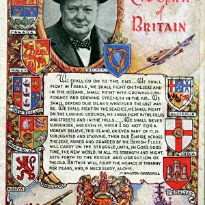
England in the Ninth Century
An antique map from 1875 showing the different kingdoms of England in the 9th century
Unleash your creativity and transform your space into a visual masterpiece!
duncan1890
Media ID 18838287
© Duncan Walker
Ancient History Middle Ages Anglo
Photo Mug
Introducing the Media Storehouse Photo Mug, featuring an exquisite historical image of "England in the Ninth Century" by duncan1890 from Fine Art Storehouse. This antique map transports you back in time, showcasing the intricate details of the different kingdoms that once ruled England during the 9th century. Our high-quality mugs not only keep your favorite beverage warm but also serve as a captivating conversation starter. Embrace the rich history of England with every sip.
A personalised photo mug blends sentimentality with functionality, making an ideal gift for cherished loved ones, close friends, or valued colleagues. Preview may show both sides of the same mug.
Elevate your coffee or tea experience with our premium white ceramic mug. Its wide, comfortable handle makes drinking easy, and you can rely on it to be both microwave and dishwasher safe. Sold in single units, preview may show both sides of the same mug so you can see how the picture wraps around.
Mug Size is 9.5cm high x 8cm diameter (3.7" x 3.1")
These are individually made so all sizes are approximate
FEATURES IN THESE COLLECTIONS
> Fine Art Storehouse
> Map
> Historical Maps
> Europe
> United Kingdom
> England
> Maps
> Europe
> United Kingdom
> England
> Posters
> Europe
> United Kingdom
> England
> Related Images
> Historic
> Ancient civilizations
> Maps and Charts
> Early Maps
> Maps and Charts
> Related Images
EDITORS COMMENTS
This print takes us on a journey back in time to the ninth century, offering a glimpse into the ancient history and civilization of England. An exquisite antique map from 1875, it meticulously showcases the diverse kingdoms that once thrived across this land during the middle ages. The intricate details and delicate craftsmanship of this piece truly transport us to an era long gone. As we gaze upon this remarkable artwork by duncan1890, we are reminded of the rich tapestry woven by our ancestors. Each kingdom is carefully delineated, revealing their unique territories and boundaries. From Wessex to Mercia, Northumbria to East Anglia, these distinct regions come alive before our eyes. The sepia tones lend an air of nostalgia and reverence to this historical masterpiece. It serves as a testament to the enduring legacy left behind by those who came before us – their struggles, triumphs, and contributions shaping the very fabric of England's identity. Whether you are a history enthusiast or simply appreciate fine art with a touch of antiquity, this print offers both aesthetic pleasure and intellectual stimulation. Displayed proudly on any wall or shelf, it sparks curiosity about our roots while serving as a reminder that even in today's fast-paced world, echoes from centuries past continue to resonate within us all.
MADE IN THE UK
Safe Shipping with 30 Day Money Back Guarantee
FREE PERSONALISATION*
We are proud to offer a range of customisation features including Personalised Captions, Color Filters and Picture Zoom Tools
SECURE PAYMENTS
We happily accept a wide range of payment options so you can pay for the things you need in the way that is most convenient for you
* Options may vary by product and licensing agreement. Zoomed Pictures can be adjusted in the Basket.