Photo Mug > Fine Art Storehouse > Map
Photo Mug : Map of Central Europe 1883


![]()
Home Decor from Fine Art Storehouse
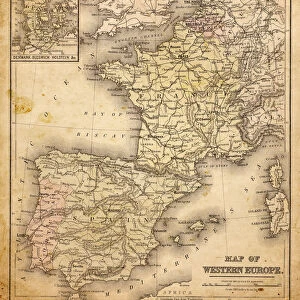
Map of Central Europe 1883
Warrens Common School Geography
Unleash your creativity and transform your space into a visual masterpiece!
THEPALMER
Media ID 13669371
© This content is subject to copyright
Austria Paper Poland Switzerland Turkey Middle East
Photo Mug
Add a touch of history to your morning routine with our Media Storehouse Photo Mug featuring the captivating "Map of Central Europe 1883" by THEPALMER from Fine Art Storehouse. This vintage geography map, reminiscent of Warrens Common School, brings a sense of adventure and exploration to your daily coffee or tea. Each mug is expertly printed with high-quality, vibrant colors that bring the intricate details of the map to life. Perfect for history enthusiasts, world travelers, or anyone who appreciates the beauty of classic cartography, this mug is a unique and thoughtful gift for any occasion. Embrace the past while enjoying your favorite beverage in the present.
A personalised photo mug blends sentimentality with functionality, making an ideal gift for cherished loved ones, close friends, or valued colleagues. Preview may show both sides of the same mug.
Elevate your coffee or tea experience with our premium white ceramic mug. Its wide, comfortable handle makes drinking easy, and you can rely on it to be both microwave and dishwasher safe. Sold in single units, preview may show both sides of the same mug so you can see how the picture wraps around.
Mug Size is 9.5cm high x 8cm diameter (3.7" x 3.1")
These are individually made so all sizes are approximate
FEATURES IN THESE COLLECTIONS
> Fine Art Storehouse
> The Magical World of Illustration
> Palmer Illustrated Collection
> Fine Art Storehouse
> Map
> Historical Maps
> Fine Art Storehouse
> Map
> Italian Maps
> Fine Art Storehouse
> Map
> USA Maps
EDITORS COMMENTS
This print showcases a remarkable piece of history - the "Map of Central Europe 1883" from Warrens Common School Geography. The image takes us back to a time when cartography was an art form, meticulously engraved on paper with great precision and attention to detail. The map itself is a treasure trove of information, depicting the political boundaries and physical geography of Central Europe during that era. From Poland to Turkey, from Austria to Germany, from Switzerland to Italy - this comprehensive representation offers a fascinating glimpse into the region's past. The engraving technique used in creating this map adds an air of nostalgia and authenticity. Each line and contour tells a story, reminding us of the painstaking efforts made by cartographers in their quest for accuracy. As we admire this antique masterpiece, it transports us back in time, allowing us to appreciate how our understanding of geography has evolved over centuries. It serves as a reminder that maps are not just tools for navigation but also windows into different eras and cultures. "The Map of Central Europe 1883" by THEPALMER is more than just an old piece of paper; it is a testament to human curiosity and exploration. Whether displayed in homes or educational institutions, this print invites viewers on an enchanting journey through time while celebrating the artistry behind historical cartography.
MADE IN THE UK
Safe Shipping with 30 Day Money Back Guarantee
FREE PERSONALISATION*
We are proud to offer a range of customisation features including Personalised Captions, Color Filters and Picture Zoom Tools
SECURE PAYMENTS
We happily accept a wide range of payment options so you can pay for the things you need in the way that is most convenient for you
* Options may vary by product and licensing agreement. Zoomed Pictures can be adjusted in the Basket.