Photo Mug > Europe > France > Paris > Maps
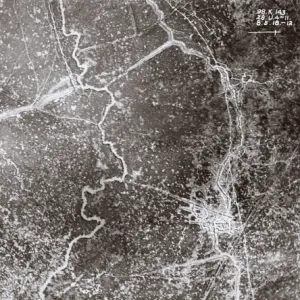
Photo Mug : Namur and the surrounding area, from Atlas de Louis XIV. Plans des places etrangeres


![]()
Home Decor from Fine Art Finder
Namur and the surrounding area, from Atlas de Louis XIV. Plans des places etrangeres
XIR271730 Namur and the surrounding area, from Atlas de Louis XIV. Plans des places etrangeres, 1665 (pen, ink & wash) by French School, (17th century); Bibliotheque du Genie, Paris, France; (add.info.: atlas of foreign places made for the French king, Louis XIV (1638-1715); ); French, out of copyright
Media ID 18254523
© Bibliotheque du Genie, Paris, France / Bridgeman Images
Photo Mug
Bring a piece of history to your morning routine with our Media Storehouse Photo Mug featuring the stunning, 17th-century view of Namur and its surrounding area from Atlas de Louis XIV. This exquisite image, sourced from Bridgeman Images through Fine Art Finder, showcases the intricate details of the French School pen, ink & wash artwork. Each mug is expertly printed with high-quality, vibrant colors to bring the rich history of Namur to life. Start your day with a cup of coffee or tea and a reminder of the beauty and history of this Belgian city.
A personalised photo mug blends sentimentality with functionality, making an ideal gift for cherished loved ones, close friends, or valued colleagues. Preview may show both sides of the same mug.
Elevate your coffee or tea experience with our premium white ceramic mug. Its wide, comfortable handle makes drinking easy, and you can rely on it to be both microwave and dishwasher safe. Sold in single units, preview may show both sides of the same mug so you can see how the picture wraps around.
Mug Size is 8cm high x 9.5cm diameter (3.1" x 3.7")
These are individually made so all sizes are approximate
FEATURES IN THESE COLLECTIONS
> Fine Art Finder
> Schools
> French School
> Aerial Photography
> Belgium
> Aerial Photography
> Related Images
> Europe
> Belgium
> Aerial Views
> Europe
> Belgium
> Related Images
> Europe
> France
> Paris
> Maps
EDITORS COMMENTS
This print showcases the enchanting city of Namur and its surrounding area, as depicted in the Atlas de Louis XIV. Plans des places etrangeres. Created by the French School in the 17th century, this pen, ink, and wash masterpiece offers a bird's-eye view of Namur's intricate cartography. The image takes us on a journey through time, back to an era when walls fortified cities and maps were meticulously hand-drawn. The attention to detail is awe-inspiring; every street, building, and landmark is intricately captured with precision. Namur emerges from the page like a hidden gem nestled amidst lush greenery. Its majestic walls encircle the city protectively while offering glimpses into its rich history. The aerial perspective allows us to appreciate not only Namur but also its picturesque surroundings that stretch far beyond what meets the eye. As we delve deeper into this artwork, we are transported to Wallonia in Belgium – a region steeped in cultural heritage and natural beauty. This map serves as a testament to King Louis XIV's fascination with foreign lands and his desire for knowledge about distant territories. This remarkable piece from Bibliotheque du Genie invites us to explore Namur's past while igniting our curiosity about how it has evolved over centuries. It reminds us of the power of art to preserve history and transport us across time and space without ever leaving our present moment.
MADE IN THE UK
Safe Shipping with 30 Day Money Back Guarantee
FREE PERSONALISATION*
We are proud to offer a range of customisation features including Personalised Captions, Color Filters and Picture Zoom Tools
SECURE PAYMENTS
We happily accept a wide range of payment options so you can pay for the things you need in the way that is most convenient for you
* Options may vary by product and licensing agreement. Zoomed Pictures can be adjusted in the Basket.