Photo Mug > Europe > United Kingdom > England > London > Sights > St Pauls Cathedral
Photo Mug : A New Map of the Roman Empire, from A Prospect of the Most Famous Parts of the World, pub


![]()
Home Decor from Fine Art Finder
A New Map of the Roman Empire, from A Prospect of the Most Famous Parts of the World, pub
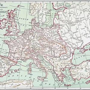
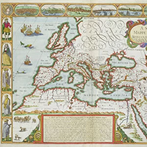
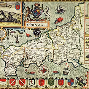
BAL42841 A New Map of the Roman Empire, from A Prospect of the Most Famous Parts of the World, pub. by Bassett & Chiswell, 1676 (hand coloured plate engraving) by Speed, John (1552-1629); O Shea Gallery, London, UK; (add.info.: Inscription reads A New Mappe of the Romane Empire, newly described by John Speede, and are to be sold by Tho. Bassett in Fleet Street, & Ric Chiswell in St Pauls Churchyard; The atlas was originally printed by George Humble in 1627, but Bassett & Chiswell published their own edition in 1676; ); English, out of copyright
Media ID 12879686
© www.bridgemanimages.com
Alexandria Constantinople Genoa Jerusalem Mapping Traditional Costume
Photo Mug
Introducing the Media Storehouse Photo Mug, a unique and captivating way to enjoy your favorite beverage while immersing yourself in history. This mug features an exquisite image of "A New Map of the Roman Empire" taken from the publication "A Prospect of the Most Famous Parts of the World," published by Bassett & Chiswell in 1676. The intricately detailed hand-colored plate engraving by Speed, now available as a high-quality print on our Photo Mugs, transports you back in time to the Roman Empire. Each mug is expertly printed using state-of-the-art technology to ensure vibrant and long-lasting images. Perfect for history enthusiasts, avid collectors, or anyone appreciating the beauty of fine art, this Photo Mug is sure to become a cherished addition to your daily routine.
A personalised photo mug blends sentimentality with functionality, making an ideal gift for cherished loved ones, close friends, or valued colleagues. Preview may show both sides of the same mug.
Elevate your coffee or tea experience with our premium white ceramic mug. Its wide, comfortable handle makes drinking easy, and you can rely on it to be both microwave and dishwasher safe. Sold in single units, preview may show both sides of the same mug so you can see how the picture wraps around.
Mug Size is 8cm high x 9.5cm diameter (3.1" x 3.7")
These are individually made so all sizes are approximate
FEATURES IN THESE COLLECTIONS
> Fine Art Finder
> Artists
> John Speed
> Fine Art Finder
> Maps (celestial & Terrestrial)
> Arts
> Artists
> C
> Thomas Churchyard
> Arts
> Artists
> H
> Thomas Hand
> Arts
> Artists
> R
> Roman Roman
> Arts
> Artists
> S
> John Speed
> Arts
> Portraits
> Pop art gallery
> Street art portraits
> Europe
> Italy
> Lazio
> Rome
> Europe
> Italy
> Liguria
> Genoa
> Europe
> Related Images
> Europe
> United Kingdom
> England
> London
> Related Images
> Europe
> United Kingdom
> England
> London
> Sights
> St Pauls Cathedral
> Maps and Charts
> Popular Maps
EDITORS COMMENTS
This print showcases "A New Map of the Roman Empire" from John Speede's renowned atlas, "A Prospect of the Most Famous Parts of the World". Published in 1676 by Bassett & Chiswell, this hand-colored plate engraving offers a fascinating glimpse into cartography during the 17th century. The map itself is intricately detailed and beautifully rendered, depicting various regions within the vast Roman Empire. From Rome to Genoa, Jerusalem to Venice, Constantinople to Alexandria, each city is marked with precision and accompanied by illustrations of traditional costumes. John Speede's expertise in mapping shines through as he presents an accurate representation of Europe during ancient times. The inscription on the map reads: "A New Mappe of the Romane Empire, newly described by John Speede". This particular edition was published by Thomas Bassett and Richard Chiswell, who released their own version after George Humble's original printing in 1627. The historical significance and meticulous craftsmanship make this print a true collector's item for enthusiasts of plan, mapping, and cartography. Displayed at O Shea Gallery in London, UK, this print transports viewers back in time as they explore the expansive territories once ruled by one of history's greatest empires. Whether you are a history buff or simply appreciate fine artistry, this image invites you to delve into centuries past and marvel at both human ingenuity and artistic skill.
MADE IN THE UK
Safe Shipping with 30 Day Money Back Guarantee
FREE PERSONALISATION*
We are proud to offer a range of customisation features including Personalised Captions, Color Filters and Picture Zoom Tools
SECURE PAYMENTS
We happily accept a wide range of payment options so you can pay for the things you need in the way that is most convenient for you
* Options may vary by product and licensing agreement. Zoomed Pictures can be adjusted in the Basket.