Photo Mug > Europe > France > Canton > Landes
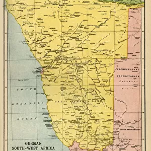
Photo Mug : Map Of German South-West Africa At Beginning Of First World War. From The Great World War A History Volume Iii, Published 1916


![]()
Home Decor from Design Pics
Map Of German South-West Africa At Beginning Of First World War. From The Great World War A History Volume Iii, Published 1916
Design Pics offers Distinctively Different Imagery representing over 1,500 contributors
Media ID 18190099
© Ken Welsh / Design Pics
Africa First German Great Land Namibia South South West West World Namaqua
Photo Mug
Add a touch of history to your daily routine with our Media Storehouse Photo Mugs. Featuring an intriguing image of a Map of German South-West Africa at the beginning of the First World War, taken from "The Great World War A History Volume III," published in 1916 by Ken Welsh from Design Pics. Each mug holds your favorite beverage and serves as a captivating conversation starter. Perfect for history enthusiasts, collectors, or anyone who appreciates the beauty of vintage maps. Embrace the past with our high-quality, full-color photo mugs.
A personalised photo mug blends sentimentality with functionality, making an ideal gift for cherished loved ones, close friends, or valued colleagues. Preview may show both sides of the same mug.
Elevate your coffee or tea experience with our premium white ceramic mug. Its wide, comfortable handle makes drinking easy, and you can rely on it to be both microwave and dishwasher safe. Sold in single units, preview may show both sides of the same mug so you can see how the picture wraps around.
Mug Size is 9.5cm high x 8cm diameter (3.7" x 3.1")
These are individually made so all sizes are approximate
FEATURES IN THESE COLLECTIONS
> Africa
> Namibia
> Related Images
> Africa
> South Africa
> Maps
> Africa
> South Africa
> Related Images
> Europe
> France
> Canton
> Landes
> Maps and Charts
> Related Images
> Maps and Charts
> World
EDITORS COMMENTS
This print showcases a historical map of German South-West Africa at the onset of the First World War. Published in 1916 as part of "The Great World War: A History Volume III" this illustration offers an intriguing glimpse into a pivotal moment in time. The map vividly depicts the vast expanse of land that encompasses Namibia, known then as German South-West Africa. With meticulous detail, every contour and boundary is meticulously outlined, allowing viewers to immerse themselves in the geography and topography of this region. From the arid plains of Namaqualand to the untamed wilderness stretching across Namibia, this map captures both the beauty and complexity of German South-West Africa. As we reflect on history's turning points, it becomes apparent that this particular map holds immense significance. It represents not only a geographical snapshot but also serves as a visual reminder of how global conflicts can shape nations and territories. Ken Welsh's expert craftsmanship brings life to this vintage piece, preserving its authenticity for generations to come. Whether you are an avid historian or simply captivated by cartography, this print invites you to explore an era when borders were redrawn and alliances tested amidst the chaos of war.
MADE IN THE UK
Safe Shipping with 30 Day Money Back Guarantee
FREE PERSONALISATION*
We are proud to offer a range of customisation features including Personalised Captions, Color Filters and Picture Zoom Tools
SECURE PAYMENTS
We happily accept a wide range of payment options so you can pay for the things you need in the way that is most convenient for you
* Options may vary by product and licensing agreement. Zoomed Pictures can be adjusted in the Basket.