Fraud Blocker Skip to main content

Home > North America > Martinique > Maps

Maps Collection

Maps of Martinique North America are a series that depict the Caribbean island nation of Martinique

Choose a picture from our Maps Collection for your Wall Art and Photo Gifts

33 items

Background imageMaps Collection: Geography map: representation of part of the archipelago of the small Antilles

Geography map: representation of part of the archipelago of the small Antilles (island of Saint Lucia, Martinique)
VEN5030211 Geography map: representation of part of the archipelago of the small Antilles (island of Saint Lucia, Martinique, Dominica, Ile des Saintes, Guadeloupe, Montserrat, Antigua, Barbuda)

Background imageMaps Collection: Geography map: representation of the island of Martinique in the small Antilles

Geography map: representation of the island of Martinique in the small Antilles
VEN5030213 Geography map: representation of the island of Martinique in the small Antilles, made by Dutch cartographer Gerard van Keulen (1678-1726) 1709-1713

Background imageMaps Collection: Plan of the harbour, fort, town and environs of Fort Royal in Martinique, 1793 (engraving)

Plan of the harbour, fort, town and environs of Fort Royal in Martinique, 1793 (engraving)
7340437 Plan of the harbour, fort, town and environs of Fort Royal in Martinique, 1793 (engraving) by Booth, William (18th century); 88x70 cm; National Maritime Museum, London

Background imageMaps Collection: Map of the Caribbean island of Martinique, c1783

Map of the Caribbean island of Martinique, c1783

Background imageMaps Collection: Geography Atlas: representation of the island of Martinique in the West Indies

Geography Atlas: representation of the island of Martinique in the West Indies
VEN5029597 Geography Atlas: representation of the island of Martinique in the West Indies. Map taken from "The west indian atlas or general description of west indies" by Thomas Jefferys

Background imageMaps Collection: Map of Martinique, 1666 - 1667, engraving

Map of Martinique, 1666 - 1667, engraving
1758849 Map of Martinique, 1666 - 1667, engraving; (add.info.: Map of Martinique, 1666 - 1667, engraving); Photo: Tallandier

Background imageMaps Collection: Map of Martinique, c.1900 (engraving)

Map of Martinique, c.1900 (engraving)
533483 Map of Martinique, c.1900 (engraving); (add.info.: Map of Martinique, circa 1902, from the 10th edition of Encyclopaedia Britannica.); Encyclopaedia Britannica/UIG

Background imageMaps Collection: Milton Keynes MK3 5 Map

Milton Keynes MK3 5 Map
Postcode Sector Map of Milton Keynes MK3 5

Background imageMaps Collection: Blackburn with Darwen BB3 0 Map

Blackburn with Darwen BB3 0 Map
Postcode Sector Map of Blackburn with Darwen BB3 0

Background imageMaps Collection: 13834786

13834786

Background imageMaps Collection: Martinique (overseas department or overseas department) - France and its Colonies

Martinique (overseas department or overseas department) - France and its Colonies
XEE4144385 Martinique (overseas department or overseas department) - France and its Colonies. Atlas illustrates one hundred and five maps from the maps of the depot of war

Background imageMaps Collection: Antique French map of Guadalupe and Martinique

Antique French map of Guadalupe and Martinique

Background imageMaps Collection: Detailed map of the island of Martinique in the West Indies

Detailed map of the island of Martinique in the West Indies
JLJ4687641 Detailed map of the island of Martinique in the West Indies. Engraving by Matthew Seutter (1678-1757) 18th century Chartres, Musee des Beaux Arts by Seutter

Background imageMaps Collection: Map of the island of Martinique, the island of Saintes and the island of Marie Galante in

Map of the island of Martinique, the island of Saintes and the island of Marie Galante in
JLJ4687642 Map of the island of Martinique, the island of Saintes and the island of Marie Galante in the West Indies. Engraving of the 19th century Chartres, Musee des Beaux Arts by French School

Background imageMaps Collection: Map of Central America (coloured engraving)

Map of Central America (coloured engraving)
VNK284159 Map of Central America (coloured engraving) by Netherlandish School, (17th century); Vorontsov Palace, Crimea, Ukraine; (add.info)

Background imageMaps Collection: Maps of the Caribbean Islands (Guadeloupe, Marie Galante, Dominica, Martinique

Maps of the Caribbean Islands (Guadeloupe, Marie Galante, Dominica, Martinique
LRI4707035 Maps of the Caribbean Islands (Guadeloupe, Marie Galante, Dominica, Martinique, Saint Lucia, Saint Vincent, Barbados, Grenadines and Grenada) (etching, 1730) by Delisle

Background imageMaps Collection: Martinique (chromolitho)

Martinique (chromolitho)
1094293 Martinique (chromolitho) by French School, (19th century); Private Collection; (add.info.: Martinique. French educational card, late 19th or early 20th century.); © Look and Learn

Background imageMaps Collection: Guadeloupe and Martinique map 1887

Guadeloupe and Martinique map 1887
Map from La Premiere Annee de Geographie par P. Foncin - Paris 1887

Background imageMaps Collection: Torbay TQ2 8 Map

Torbay TQ2 8 Map
Postcode Sector Map of Torbay TQ2 8

Background imageMaps Collection: Wiltshire SP9 7 Map

Wiltshire SP9 7 Map
Postcode Sector Map of Wiltshire SP9 7

Background imageMaps Collection: Eastbourne BN23 5 Map

Eastbourne BN23 5 Map
Postcode Sector Map of Eastbourne BN23 5

Background imageMaps Collection: A Martinique creole woman, c1890. Artist: Henri Thiriat

A Martinique creole woman, c1890. Artist: Henri Thiriat
A Martinique creole woman, c1890. From Universal Geography, Maps & Illustrations, Vol XXXIV, Virtue & Co Limited, (London, c1890)

Background imageMaps Collection: Snake Catcher and Charcoal Girl, Martinique, c1890

Snake Catcher and Charcoal Girl, Martinique, c1890. From Universal Geography, Maps & Illustrations, Vol XXXIV, Virtue & Co Limited, (London, c1890)

Background imageMaps Collection: General view of Fort-De-France, Martinique, c1890. Artist: A Kohl

General view of Fort-De-France, Martinique, c1890. Artist: A Kohl
General view of Fort-De-France, Martinique, c1890. From Universal Geography, Maps & Illustrations, Vol XXXIV, Virtue & Co Limited, (London, c1890)

Background imageMaps Collection: King Oscar II of Sweden visiting Mont Saint-Michel, Normandy, France, 1902

King Oscar II of Sweden visiting Mont Saint-Michel, Normandy, France, 1902
Map showing the eruption of Mount Pelee, Martinique, 1902. An illustration from Le Petit Journal, 25th May 1902

Background imageMaps Collection: Map Of The Isle Of Martinique Circa. 1760. From 'Atlas De Toutes Les Parties Connues Du Globe

Map Of The Isle Of Martinique Circa. 1760. From "Atlas De Toutes Les Parties Connues Du Globe Terrestre "By
Map Of The Isle Of Martinique Circa. 1760. From " Atlas De Toutes Les Parties Connues Du Globe Terrestre " By Cartographer Rigobert Bonne. Published Geneva Circa. 1760

Background imageMaps Collection: Lieutenant-General The Honourable Robert Monckton

Lieutenant-General The Honourable Robert Monckton
Major-General (later Lieutenant-General) The Honourable Robert Monckton (1726-1782), at the Taking of Martinique, 1762.Oil on canvas by Benjamin West (1738-1820), 1763/4 (c)

Background imageMaps Collection: 1742 Covens And Mortier Map Of Martinique Topography

1742 Covens And Mortier Map Of Martinique Topography
1742, Covens and Mortier Map of Martinique

Background imageMaps Collection: 1831 Depot De La Marine Nautical Chart Or Map Of Martinique

1831 Depot De La Marine Nautical Chart Or Map Of Martinique
1831, Depot de la Marine Nautical Chart or Map of Martinique, West Indies

Background imageMaps Collection: 1814 Thomson Map Of Martinique And Dominica West Indies

1814 Thomson Map Of Martinique And Dominica West Indies
1814, Thomson Map of Martinique and Dominica, West Indies , John Thomson, 1777 - 1840, was a Scottish cartographer from Edinburgh, UK

Background imageMaps Collection: 1780 Raynal And Bonne Map Of Martinique West Indies

1780 Raynal And Bonne Map Of Martinique West Indies
1780, Raynal and Bonne Map of Martinique, West Indies, Rigobert Bonne 1727 - 1794, one of the most important cartographers of the late 18th century

Background imageMaps Collection: Chart of Jamaica, Barbados, St Christopher, Martinique, Antigua and Bermuda

Chart of Jamaica, Barbados, St Christopher, Martinique, Antigua and Bermuda, 1713 (coloured engraving)
7340629 Chart of Jamaica, Barbados, St Christopher, Martinique, Antigua and Bermuda, 1713 (coloured engraving) by Seller, John (1632-97); National Maritime Museum, London

Background imageMaps Collection: Pelerinages De La Provence De La Corse De L'Algerie Et De La Martinique (colour litho)

Pelerinages De La Provence De La Corse De L'Algerie Et De La Martinique (colour litho)
8642059 Pelerinages De La Provence De La Corse De L'Algerie Et De La Martinique (colour litho) by Clerget, Hubert (1818-1899); Private Collection; (add.info)


All Professionally Made to Order for Quick Shipping


-

Maps Collection

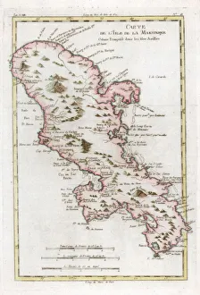
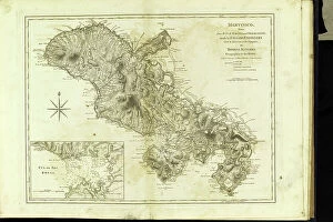
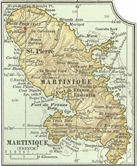
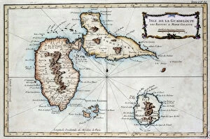
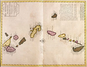
Maps of Martinique North America are a series that depict the Caribbean island nation of Martinique. These maps provide detailed information about the geography and infrastructure of the island, including roads, cities, rivers, and other features. they also include information about local attractions such as beaches and historical sites, and are available in print or digital formats for use in navigation systems or for planning trips to the area. They can an invaluable resource for travelers who want to explore this beautiful part of the world with confidence.
+

Our beautiful pictures are available as Framed Prints, Photos, Wall Art and Photo Gifts

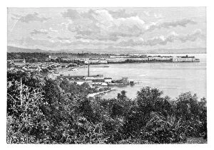
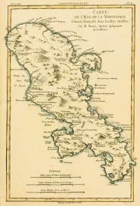
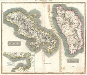
The Maps of Martinique North America collection, available on Media Storehouse, is a stunning assortment of vintage maps that depict the Caribbean island of Martinique. Our collection features highly detailed and intricate maps from various eras, including the 17th century and beyond. These maps showcase the topography and geography of Martinique as well as its surrounding areas such as Guadeloupe and Dominica. They also highlight important landmarks like Fort-de-France, Saint-Pierre, and Mount Pelée. These beautiful prints are perfect for those who love history or have an interest in cartography. They can be used to decorate homes or offices with a unique touch that adds character to any space. The high-quality paper ensures that these prints will last for years without fading or losing their vibrancy. The Maps of Martinique North America collection offers a fascinating glimpse into the past while providing a visually appealing addition to any decor style.
+

What are Maps of Martinique North America art prints?

Maps of Martinique North America art prints are high-quality reproductions of vintage maps that depict the island of Martinique in the Caribbean. These maps were created during different periods, ranging from the 17th to the early 20th century, and they provide a fascinating glimpse into how cartographers perceived this part of the world over time. These art prints showcase various features such as coastlines, rivers, mountains, towns and cities. They also include intricate details like compass roses and sea monsters that add an element of charm to these historic documents. Whether you're a history buff or simply looking for unique wall decor with a touch of nostalgia, Maps of Martinique North America art prints are sure to impress. With their rich colors and fine detail, these art prints make great additions to any home or office space. They can be framed or mounted on canvas for added durability and aesthetic appeal. Maps of Martinique North America art prints offer a beautiful way to appreciate both history and geography in one stunning package.
+

What Maps of Martinique North America art prints can I buy from Media Storehouse?

We offer a wide range of Martinique North America art prints that you can buy. These maps are perfect for those who love to explore and learn about the geography of this beautiful region. You can choose from different styles, sizes, and formats to suit your preferences. One popular option is the antique map of Martinique, which showcases the island's intricate details and topography. This print is perfect for history buffs or anyone interested in vintage cartography. Another great choice is the modern political map of North America, which highlights all countries and major cities in the region. This print is ideal for students or professionals who need an accurate reference tool. In addition to these options, Media Storehouse also offers customized maps that you can personalize with your own text or images. Whether you're looking for a unique gift or a special piece of decor for your home or office, there's sure to be a Martinique North America art print that suits your needs at Media Storehouse.
+

How do I buy Maps of Martinique North America art prints?

To buy Maps of Martinique North America art prints from Media Storehouse, you can visit their online store and browse through the available options. You can use the search bar to find specific maps or navigate through different categories such as vintage maps or contemporary maps. Once you have found a map that you like, click on it to view more details and select your preferred size and framing option if applicable. You can add the print to your cart and proceed to checkout where you will be prompted to enter your shipping information and payment details. We accept various payment methods including credit cards, PayPal, Apple Pay, Google Pay, among others. If you need any assistance during the buying process or have any questions about the product, We provide customer support via email or phone which is listed on their website. Purchasing Maps of Martinique North America art prints from Media Storehouse is a straightforward process that allows you to bring a piece of history into your home decor.
+

How much do Maps of Martinique North America art prints cost?

The cost of Maps of Martinique North America art prints varies depending on the size and type of print selected. The price range for these prints can be found on the Media Storehouse website, where you can browse through a wide selection of options to find the perfect piece for their home or office. These maps are beautifully crafted and offer a unique perspective on the geography and history of this region. Whether you're looking for a small print to hang in your living room or a large canvas to make a statement in your workspace, there is something available at an affordable price point that will suit your needs. With so many different styles and sizes to choose from, it's easy to find exactly what you're looking for when shopping with Media Storehouse.
+

How will my Maps of Martinique North America art prints be delivered to me?

Your Maps of Martinique North America art prints will be delivered to you in a secure and protective packaging. The Media Storehouse takes great care in ensuring that your artwork arrives at your doorstep without any damage or creases. Your prints will be rolled up and placed inside a sturdy tube, which is then sealed with tape to prevent any moisture or dust from entering. The delivery process is handled by trusted courier services who are experienced in handling delicate packages like artworks. You can track the progress of your shipment through their online tracking system, which provides real-time updates on the location of your package. Upon receiving your package, it's important to handle it with care when unrolling the print. It's recommended that you lay it flat for a few hours before framing or mounting it on a wall. You can expect a hassle-free delivery experience when ordering Maps of Martinique North America art prints from Media Storehouse.