
Maps Collection
Maps of Guadeloupe North America are essential tools for navigating the Caribbean island
Choose a picture from our Maps Collection for your Wall Art and Photo Gifts
21 items


All Professionally Made to Order for Quick Shipping
-
Maps Collection
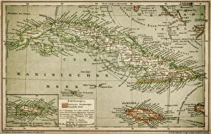
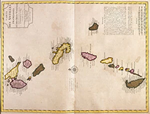
Maps of Guadeloupe North America are essential tools for navigating the Caribbean island. Located in the Lesser Antilles, Guadeloupe is an archipelago of five islands: Basse-Terre, Grande-Terre, Marie-Galante, La Desirade and Les Saintes. Maps of the region provide detailed information about roads, towns and cities as well as points of interest such as beaches, parks and monuments. They also include topographical features like mountains and rivers that can be used to plan hikes or other outdoor activities. Additionally, maps may show important landmarks like churches or historical sites that can be visited during a trip to Guadeloupe. With their help travelers can easily explore this beautiful destination without getting lost.
+
Our beautiful pictures are available as Framed Prints, Photos, Wall Art and Photo Gifts
The Maps of Guadeloupe North America collection is a fascinating assortment of vintage maps that depict the Caribbean island of Guadeloupe. Our collection, available on our wall art and framed prints platform, features maps from different eras, including those dating back to the 18th century. These maps showcase the topography, landmarks, and settlements of Guadeloupe in intricate detail. The Maps of Guadeloupe North America collection offers a unique insight into the history and geography of this beautiful island. Each map has its own story to tell about how people perceived and navigated through Guadeloupe over time. They are not only visually stunning but also provide valuable information for historians, geographers, and anyone interested in exploring this part of the world. Whether you're looking for an eye-catching piece to decorate your home or want to add a historical touch to your research project or presentation, the Maps of Guadeloupe North America collection is definitely worth checking out on our website.
+
What are Maps of Guadeloupe North America art prints?
Maps of Guadeloupe North America art prints are high-quality reproductions of vintage and contemporary maps depicting the island of Guadeloupe, located in the Caribbean Sea. These prints showcase the intricate details and unique features of this French overseas territory, including its stunning beaches, lush rainforests, and vibrant cities. These art prints are perfect for anyone who loves history, geography or travel. They make great gifts for collectors, students or enthusiasts who want to learn more about this beautiful island. Whether you're looking to decorate your home or office with a piece that reflects your interests or simply want to add a touch of sophistication to any space, Maps of Guadeloupe North America art prints are an excellent choice. With their rich colors and fine detail reproduction capabilities, these art prints capture the essence of Guadeloupe's natural beauty and cultural heritage. They come in various sizes and can be framed according to your preferences.
+
What Maps of Guadeloupe North America art prints can I buy from Media Storehouse?
We offer a wide range of Maps of Guadeloupe North America art prints that you can buy. These maps are available in different sizes and styles, including vintage, antique, and modern designs. You can choose from a variety of map types such as topographic maps, political maps, road maps, and more. Some popular options include the Vintage Map of Guadeloupe (circa 1914) which shows the island's cities and towns along with its natural features like mountains and rivers. Another option is the Antique Map of North America (1762) which includes Guadeloupe as part of the French West Indies. If you're looking for something more contemporary, Media Storehouse also offers modern satellite images that showcase Guadeloupe's stunning coastline and lush greenery. Whatever your preference may be, there is sure to be a Maps of Guadeloupe North America art print that will suit your taste at Media Storehouse.
+
How do I buy Maps of Guadeloupe North America art prints?
To purchase Maps of Guadeloupe North America art prints from Media Storehouse, you can browse our collection online and select the print that best suits your needs. Once you have found the desired artwork, simply add it to your cart and proceed to checkout. You will be prompted to enter your shipping information and payment details before finalizing the order. We offer a wide range of printing options for their art prints, including canvas, framed, or unframed prints in various sizes. We also offer different paper types such as matte or glossy finishes. If you have any questions about purchasing Maps of Guadeloupe North America art prints from Media Storehouse, our customer service team is available to assist you via email or phone. With a vast selection of high-quality artwork available for purchase on their website, buying Maps of Guadeloupe North America art prints has never been easier.
+
How much do Maps of Guadeloupe North America art prints cost?
We offer a wide range of Maps of Guadeloupe North America art prints at varying prices. The cost depends on the size, material and framing options chosen by the customer. The company provides high-quality prints that are perfect for home or office decoration, educational purposes, or as gifts for friends and family who love maps. The Maps of Guadeloupe North America art prints available at Media Storehouse come in different sizes to suit various preferences and budgets. You can choose from small to large-sized prints printed on paper or canvas materials. Framing options include unframed, framed with black or white wooden frames, among others. The cost of Maps of Guadeloupe North America art prints varies depending on several factors such as size, material and framing options selected by customers. However, Media Storehouse ensures that all their products are affordable without compromising quality standards.
+
How will my Maps of Guadeloupe North America art prints be delivered to me?
Your Maps of Guadeloupe North America art prints will be delivered to you in a safe and secure manner. The prints are carefully packaged and shipped to ensure that they arrive at your doorstep in pristine condition. Depending on the size of the print, it may be rolled up and placed inside a sturdy tube for protection during transit. The delivery method used by Media Storehouse is reliable and efficient, ensuring that your order reaches you as quickly as possible. You can expect to receive regular updates on the status of your order, including tracking information so that you can keep an eye on its progress. Once your Maps of Guadeloupe North America art prints have arrived, all that's left is for you to find the perfect spot to display them. Whether you choose to frame them or hang them as-is, these beautiful prints are sure to add a touch of elegance and sophistication to any room in which they're displayed.