Mouse Mat > North America > United States of America > Pennsylvania > Erie
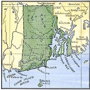
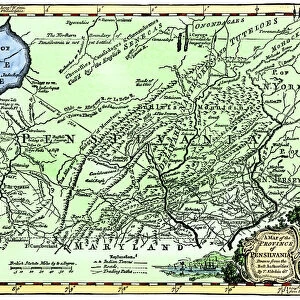
Mouse Mat : Colonial Pennsylvania map, 1750s


![]()
Home Decor from North Wind
Colonial Pennsylvania map, 1750s
Map of the " Province of Pennsilvania, " 1756.
Hand-colored 19th-century woodcut reproduction of an 18th-century illustration
North Wind Picture Archives brings history to life with stock images and hand-colored illustrations
Media ID 5882541
© North Wind Picture Archives
1700s 18th Century Colonial Colony East Eastern Lake Erie Pennsylvania 1756
Mouse Mat
A high quality photographic print manufactured into a durable wipe clean mouse mat (27x22cm) with a non slip backing, which works with all mice.
Archive quality photographic print in a durable wipe clean mouse mat with non slip backing. Works with all computer mice
Estimated Image Size (if not cropped) is 25.4cm x 21.8cm (10" x 8.6")
Estimated Product Size is 26.9cm x 21.8cm (10.6" x 8.6")
These are individually made so all sizes are approximate
Artwork printed orientated as per the preview above, with landscape (horizontal) orientation to match the source image.
FEATURES IN THESE COLLECTIONS
> Historic
> Colonial America illustrations
> 18th century America
> Historic
> Colonial America illustrations
> Colonial America
> Historic
> Colonial America illustrations
> Historic
> Colonial history
> Colonial art and artists
> North America
> Related Images
> North America
> United States of America
> Pennsylvania
> Erie
> North Wind Picture Archives
> Maps
EDITORS COMMENTS
This print showcases a hand-colored 19th-century woodcut reproduction of an 18th-century illustration, depicting the Colonial Pennsylvania map from the 1750s. The intricate details and vibrant colors bring to life this vintage piece of American history. The map, titled "Province of Pennsilvania" was originally created in 1756 and offers a fascinating glimpse into the eastern colonial region during that era. It portrays the vast territory known as Pennsylvania, one of the original thirteen colonies that would later form the United States. As we delve into this visual treasure trove, we are transported back to a time when America was still emerging as a nation. This historic illustration allows us to trace the footsteps of early settlers and explore their interactions with Native American tribes who inhabited these lands long before European colonization. From Lake Erie in the north to its southern borders, this map reveals key geographical features and settlements that played significant roles in shaping Pennsylvania's rich history. It serves as both an educational tool for historians and art enthusiasts alike. With its traditional style and attention to detail, this image encapsulates the essence of 18th-century illustrations while offering us a window into our past. As we admire this remarkable piece, let us appreciate not only its artistic value but also its ability to transport us through time on a journey through Colonial Pennsylvania's captivating story.
MADE IN THE UK
Safe Shipping with 30 Day Money Back Guarantee
FREE PERSONALISATION*
We are proud to offer a range of customisation features including Personalised Captions, Color Filters and Picture Zoom Tools
SECURE PAYMENTS
We happily accept a wide range of payment options so you can pay for the things you need in the way that is most convenient for you
* Options may vary by product and licensing agreement. Zoomed Pictures can be adjusted in the Basket.