Mouse Mat > Arts > Portraits > Pop art gallery > Street art portraits
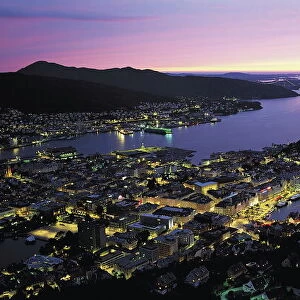
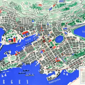
Mouse Mat : Tourist map of Bergen, Norway


![]()
Home Decor from Mary Evans Picture Library
Tourist map of Bergen, Norway
Tourist map (TKT - Turisttrafikkomiteen) of Bergen, Hordaland County, Norway. Date: 1951
Mary Evans Picture Library makes available wonderful images created for people to enjoy over the centuries
Media ID 11562494
© Mary Evans / Grenville Collins Postcard Collection
1951 Bergen Docks Hordaland Layout Norway Norwegian Plan Tourist
Mouse Mat
A high quality photographic print manufactured into a durable wipe clean mouse mat (27x22cm) with a non slip backing, which works with all mice.
Archive quality photographic print in a durable wipe clean mouse mat with non slip backing. Works with all computer mice
Estimated Image Size (if not cropped) is 25.4cm x 14.7cm (10" x 5.8")
Estimated Product Size is 26.9cm x 21.8cm (10.6" x 8.6")
These are individually made so all sizes are approximate
Artwork printed orientated as per the preview above, with landscape (horizontal) orientation to match the source image.
FEATURES IN THESE COLLECTIONS
> Arts
> Portraits
> Pop art gallery
> Street art portraits
> Europe
> Norway
> Related Images
> Maps and Charts
> Early Maps
> Maps and Charts
> Related Images
EDITORS COMMENTS
1. Title: "Exploring Bergen, Norway in 1951: A Glimpse into the Past with this Historic Tourist Map This vintage tourist map of Bergen, Norway, hails from 1951 and is a testament to the allure and charm of this enchanting Norwegian town nestled in Hordaland County. Published by the Turisttrafikkomiteen (Tourist Traffic Committee), this map invites us to take a step back in time and experience Bergen as it was over seven decades ago. The map offers a comprehensive layout of the town, from its bustling harbor and port area to the winding streets and docks that crisscross this picturesque coastal town. The intricate detailing of the map showcases the various landmarks, attractions, and points of interest that Bergen had to offer in the 1950s. Bergen, a town steeped in history, is depicted with its iconic colorful houses, known as 'turf houses,' clustered together against the backdrop of the mountains and the fjord. The map also highlights the town's rich maritime heritage, with various docks and harbor facilities marked for easy navigation. As we delve deeper into the map, we can identify several key landmarks, such as the Bergen Cathedral, the Fish Market, and the Bryggen Wharf, which continue to be popular tourist destinations even today. The map also features various transportation options, including buses, trams, and ferries, making it an invaluable resource for travelers exploring Bergen in the 1950s. This historic tourist map of Bergen, Norway, is not only a fascinating glimpse into the past but also an intriguing reminder of the enduring charm and allure of this beautiful Norwegian town. Whether you're an armchair traveler or planning a trip to Norway, this map is a must-have for anyone interested in the history and culture of Bergen and Norway as a whole.
MADE IN THE UK
Safe Shipping with 30 Day Money Back Guarantee
FREE PERSONALISATION*
We are proud to offer a range of customisation features including Personalised Captions, Color Filters and Picture Zoom Tools
SECURE PAYMENTS
We happily accept a wide range of payment options so you can pay for the things you need in the way that is most convenient for you
* Options may vary by product and licensing agreement. Zoomed Pictures can be adjusted in the Basket.