Mouse Mat > Historic > Ancient civilizations > Ancient Greece > Greek history
Mouse Mat : MAP / EUROPE / GREECE / HOMER


![]()
Home Decor from Mary Evans Picture Library
MAP / EUROPE / GREECE / HOMER
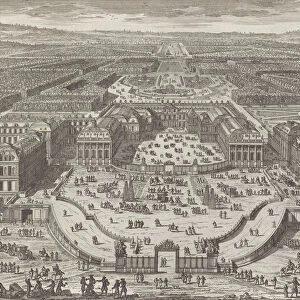
Map of Ancient Greece, Phrygia and Crete at the time of Homer Date: BC
Mary Evans Picture Library makes available wonderful images created for people to enjoy over the centuries
Media ID 20153867
© Bubblepunk
Mouse Mat
A high quality photographic print manufactured into a durable wipe clean mouse mat (27x22cm) with a non slip backing, which works with all mice.
Archive quality photographic print in a durable wipe clean mouse mat with non slip backing. Works with all computer mice
Estimated Image Size (if not cropped) is 25.4cm x 16.9cm (10" x 6.7")
Estimated Product Size is 26.9cm x 21.8cm (10.6" x 8.6")
These are individually made so all sizes are approximate
Artwork printed orientated as per the preview above, with landscape (horizontal) orientation to match the source image.
FEATURES IN THESE COLLECTIONS
> Mary Evans Prints Online
> New Images July 2020
> Europe
> Greece
> Related Images
> Europe
> Related Images
> Historic
> Ancient civilizations
> Ancient Greece
> Greek history
> Maps and Charts
> Early Maps
> Maps and Charts
> Related Images
EDITORS COMMENTS
This map print transports us back in time to ancient Greece, Phrygia, and Crete, as depicted in maps from the era of Homer (circa 8th-9th century BC). The map provides a fascinating glimpse into the geographical knowledge and cultural understanding of the ancient world. Centered on Europe, the map extends eastward to include the Anatolian Peninsula, where Phrygia and other ancient civilizations thrived. Phrygia, located in modern-day Turkey, is depicted as a significant power, occupying a vast territory between the Aegean Sea and the Black Sea. To the south, the map reveals the island of Crete, a crucial player in the Mediterranean world during Homer's time. The labyrinthine island, home to the legendary Minotaur and the hero Theseus, is accurately represented with its major cities and landmarks. The map also highlights various other ancient Greek city-states, such as Athens, Sparta, and Thebes, providing context for the epic tales of Homer's Iliad and Odyssey. The intricate details and accurate representation of geographical features make this map an essential resource for scholars, historians, and anyone with an interest in ancient civilizations. This map offers a captivating window into the world of Homer and the ancient civilizations of Greece, Phrygia, and Crete. Its intricate details and historical significance make it a must-have for any collection focused on ancient history or cartography.
MADE IN THE UK
Safe Shipping with 30 Day Money Back Guarantee
FREE PERSONALISATION*
We are proud to offer a range of customisation features including Personalised Captions, Color Filters and Picture Zoom Tools
SECURE PAYMENTS
We happily accept a wide range of payment options so you can pay for the things you need in the way that is most convenient for you
* Options may vary by product and licensing agreement. Zoomed Pictures can be adjusted in the Basket.