Mouse Mat > Europe > United Kingdom > Wales > Maps
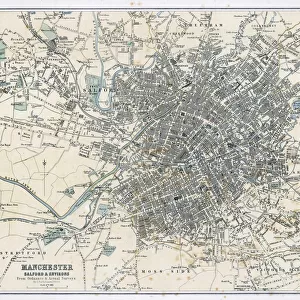
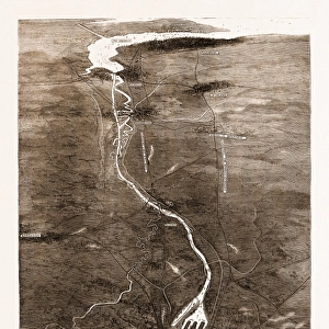
Mouse Mat : Old Map of Sheffield 1893 from the Comprehensive Gazetteer Atlas of England and Wales


![]()
Home Decor from MapSeeker
Old Map of Sheffield 1893 from the Comprehensive Gazetteer Atlas of England and Wales
J112
Welcome to the Mapseeker Image library and enter an historic gateway to one of the largest on-line collections of Historic Maps, Nostalgic Views, Vista's and Panorama's from a World gone by.
Media ID 20347138
Historic Map Old Town Plan Sheffield William Mackenzie
Mouse Mat
A high quality photographic print manufactured into a durable wipe clean mouse mat (27x22cm) with a non slip backing, which works with all mice.
Archive quality photographic print in a durable wipe clean mouse mat with non slip backing. Works with all computer mice
Estimated Image Size (if not cropped) is 25.4cm x 16.9cm (10" x 6.7")
Estimated Product Size is 26.9cm x 21.8cm (10.6" x 8.6")
These are individually made so all sizes are approximate
Artwork printed orientated as per the preview above, with landscape (horizontal) orientation to match the source image.
FEATURES IN THESE COLLECTIONS
> MapSeeker
> British Town And City Plans
> English & Welsh PORTFOLIO
> Europe
> United Kingdom
> England
> Maps
> Europe
> United Kingdom
> England
> Sheffield
> Europe
> United Kingdom
> Wales
> Maps
> Europe
> United Kingdom
> Wales
> Posters
> Europe
> United Kingdom
> Wales
> Related Images
> Maps and Charts
> Related Images
> Maps and Charts
> Wales
EDITORS COMMENTS
This print showcases an exquisite piece of history - the Old Map of Sheffield from 1893. Taken from the Comprehensive Gazetteer Atlas of England and Wales, this map offers a fascinating glimpse into the past, allowing us to explore the city's rich heritage. With intricate details and stunning craftsmanship, this old map takes us on a journey through time, revealing Sheffield as it stood over a century ago. Every street, building, and landmark is meticulously depicted, offering a comprehensive town plan that captures the essence of this bustling industrial hub. As we study this historic Sheffield map, we can't help but marvel at how much has changed since its creation. The evolution of urban landscapes becomes evident as new developments replace once-familiar structures. Yet amidst these transformations lies an undeniable sense of nostalgia for bygone eras. William Mackenzie's Comprehensive Gazetteer Atlas ensures that future generations can appreciate and understand Sheffield's roots. This print serves as a testament to his dedication in preserving our collective history. Whether you are a historian seeking insights into Sheffield's past or simply captivated by vintage cartography, this Old Map of Sheffield is sure to ignite your imagination. Let yourself be transported back in time as you trace the streets and landmarks that have shaped one of England's most vibrant cities.
MADE IN THE UK
Safe Shipping with 30 Day Money Back Guarantee
FREE PERSONALISATION*
We are proud to offer a range of customisation features including Personalised Captions, Color Filters and Picture Zoom Tools
SECURE PAYMENTS
We happily accept a wide range of payment options so you can pay for the things you need in the way that is most convenient for you
* Options may vary by product and licensing agreement. Zoomed Pictures can be adjusted in the Basket.