Mouse Mat > Africa > Morocco > Maps
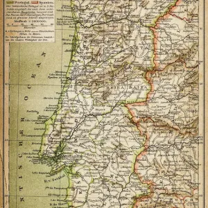
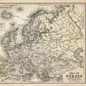
Mouse Mat : Antique illustration from US navy and army: Spain, Portugal, Morocco and Canary Islands map


![]()
Home Decor from Fine Art Storehouse
Antique illustration from US navy and army: Spain, Portugal, Morocco and Canary Islands map
Unleash your creativity and transform your space into a visual masterpiece!
ilbusca
Media ID 18298727
Mouse Mat
A high quality photographic print manufactured into a durable wipe clean mouse mat (27x22cm) with a non slip backing, which works with all mice.
Archive quality photographic print in a durable wipe clean mouse mat with non slip backing. Works with all computer mice
Estimated Image Size (if not cropped) is 20.6cm x 25.4cm (8.1" x 10")
Estimated Product Size is 21.8cm x 26.9cm (8.6" x 10.6")
These are individually made so all sizes are approximate
Artwork printed orientated as per the preview above, with portrait (vertical) orientation to match the source image.
FEATURES IN THESE COLLECTIONS
> Fine Art Storehouse
> Map
> Historical Maps
> Fine Art Storehouse
> Travel Imagery
> Travel Destinations
> Morocco, North Africa
> Africa
> Morocco
> Related Images
> Europe
> Portugal
> Related Images
> Europe
> Spain
> Related Images
> Maps and Charts
> Related Images
EDITORS COMMENTS
This print titled "Antique illustration from US navy and army: Spain, Portugal, Morocco and Canary Islands map" takes us on a historical journey through the intricate cartography of yesteryears. With its rich details and exquisite craftsmanship, this piece showcases the expertise of the artists who meticulously crafted maps for the United States Navy and Army. The map itself encompasses an expansive region, spanning across Spain, Portugal, Morocco, and the Canary Islands. Its vintage charm transports us to a time when exploration was at its peak and these lands held great allure for adventurers seeking new horizons. Every line drawn on this antique illustration tells a story of discovery and conquest. It serves as a testament to human curiosity and ambition that drove explorers to brave uncharted territories in search of knowledge and riches. As we gaze upon this remarkable artwork by ilbusca from Fine Art Storehouse, we are reminded of how far we have come in our understanding of geography while appreciating the artistry behind these early navigational tools. This print is not just an aesthetic delight but also a window into history—an invitation to explore our past with fresh eyes. Whether displayed in homes or offices, this print will undoubtedly spark conversations about exploration's golden age while adding a touch of elegance to any space.
MADE IN THE UK
Safe Shipping with 30 Day Money Back Guarantee
FREE PERSONALISATION*
We are proud to offer a range of customisation features including Personalised Captions, Color Filters and Picture Zoom Tools
FREE COLORIZATION SERVICE
You can choose advanced AI Colorization for this picture at no extra charge!
SECURE PAYMENTS
We happily accept a wide range of payment options so you can pay for the things you need in the way that is most convenient for you
* Options may vary by product and licensing agreement. Zoomed Pictures can be adjusted in the Basket.