Mouse Mat > Fine Art Storehouse > Map
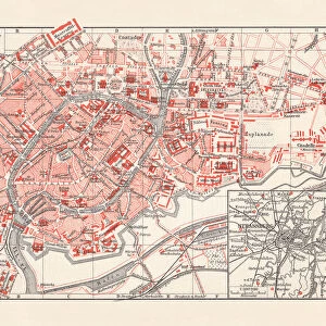
Mouse Mat : Strasbourg map 1895


![]()
Home Decor from Fine Art Storehouse
Strasbourg map 1895
Meyers Konversations-Lexikon. Ein Nachschlagewerk des allgemeinen Wissens, 5th edition 17 volumes Bibliographisches Institut - Leipzig 1895-1897
Unleash your creativity and transform your space into a visual masterpiece!
THEPALMER
Media ID 13609303
© This content is subject to copyright
Mouse Mat
A high quality photographic print manufactured into a durable wipe clean mouse mat (27x22cm) with a non slip backing, which works with all mice.
Archive quality photographic print in a durable wipe clean mouse mat with non slip backing. Works with all computer mice
Estimated Image Size (if not cropped) is 25.4cm x 17.2cm (10" x 6.8")
Estimated Product Size is 26.9cm x 21.8cm (10.6" x 8.6")
These are individually made so all sizes are approximate
Artwork printed orientated as per the preview above, with landscape (horizontal) orientation to match the source image.
FEATURES IN THESE COLLECTIONS
> Fine Art Storehouse
> Map
> Historical Maps
EDITORS COMMENTS
This print showcases a remarkable piece of history, the "Strasbourg map 1895" from Meyers Konversations-Lexikon. This exquisite creation takes us back to the enchanting city of Strasbourg in France during the late 19th century. The map, meticulously engraved and etched with intricate details, offers a glimpse into the physical geography and cartography of that era. The artist behind this masterpiece, known as THEPALMER, has skillfully captured every nuance of this antique illustration. The horizontal composition allows for an immersive experience as we explore the streets and landmarks of Strasbourg through its delicate lines and expert shading. As we delve deeper into this print, we are transported to a time when technology had not yet dominated our lives. It serves as a reminder of how maps were once cherished possessions used for navigation and exploration. This particular map is part of Meyers Konversations-Lexikon's fifth edition, published between 1895-1897 by Bibliographisches Institut in Leipzig. Whether you have personal ties to Alsace or simply appreciate historical artifacts, this print is sure to captivate your imagination. Hang it on your wall or display it proudly in your study; let it be a conversation starter that sparks curiosity about the past while adding an air of sophistication to any space.
MADE IN THE UK
Safe Shipping with 30 Day Money Back Guarantee
FREE PERSONALISATION*
We are proud to offer a range of customisation features including Personalised Captions, Color Filters and Picture Zoom Tools
SECURE PAYMENTS
We happily accept a wide range of payment options so you can pay for the things you need in the way that is most convenient for you
* Options may vary by product and licensing agreement. Zoomed Pictures can be adjusted in the Basket.