Mouse Mat > Europe > Norway > Maps
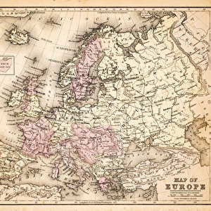
Mouse Mat : Denmark Sweden Norway map 1867


![]()
Home Decor from Fine Art Storehouse
Denmark Sweden Norway map 1867
Mitchellas Modern Atlas - Published by E.H. Butler and Co - Philadelphia 1867
Unleash your creativity and transform your space into a visual masterpiece!
THEPALMER
Media ID 13609221
© This content is subject to copyright
Denmark Norway Russia Scandinavia Sweden Rusia
Mouse Mat
A high quality photographic print manufactured into a durable wipe clean mouse mat (27x22cm) with a non slip backing, which works with all mice.
Archive quality photographic print in a durable wipe clean mouse mat with non slip backing. Works with all computer mice
Estimated Image Size (if not cropped) is 21.8cm x 25.4cm (8.6" x 10")
Estimated Product Size is 21.8cm x 26.9cm (8.6" x 10.6")
These are individually made so all sizes are approximate
Artwork printed orientated as per the preview above, with portrait (vertical) orientation to match the source image.
FEATURES IN THESE COLLECTIONS
> Fine Art Storehouse
> Map
> Denmark Maps
> Fine Art Storehouse
> Map
> Historical Maps
> Europe
> Denmark
> Related Images
> Europe
> Norway
> Related Images
> Europe
> Russia
> Related Images
EDITORS COMMENTS
This print showcases a remarkable piece of history - the Denmark Sweden Norway map from 1867. Published by E. H. Butler and Co in Philadelphia, this exquisite map is a testament to the artistry and precision of cartography during that era. The intricate details etched onto the paper through engraving and lithography transport us back to a time when physical geography was meticulously documented. The map encompasses not only Denmark, Sweden, and Norway but also Russia and other parts of Scandinavia. Its vertical orientation adds an elegant touch to its overall aesthetic appeal. As we gaze upon this antique masterpiece, we are reminded of the immense effort put into creating such comprehensive representations of our world. THEPALMER's skillful capture allows us to appreciate every minute detail with clarity and depth. The fine lines tracing coastlines, rivers, mountains, and borders tell stories of exploration, trade routes, and cultural connections between nations. As we admire this vintage treasure from Fine Art Storehouse's collection, it serves as a reminder that maps are not merely tools for navigation but windows into our past. They offer glimpses into how societies perceived their surroundings centuries ago. Let this enchanting photograph transport you back in time as you delve into the rich history embedded within each stroke on this old-world map - an enduring testament to human curiosity about our planet's wonders.
MADE IN THE UK
Safe Shipping with 30 Day Money Back Guarantee
FREE PERSONALISATION*
We are proud to offer a range of customisation features including Personalised Captions, Color Filters and Picture Zoom Tools
SECURE PAYMENTS
We happily accept a wide range of payment options so you can pay for the things you need in the way that is most convenient for you
* Options may vary by product and licensing agreement. Zoomed Pictures can be adjusted in the Basket.