Mouse Mat > Arts > Artists > L > Guillaume Le Testu
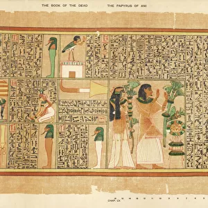
Mouse Mat : Fol. 10v Map of Scandinavia and Northern Russia, from Cosmographie Universelle


Resolution may be poor at this size (54 DPI)
![]()
Home Decor from Fine Art Finder
Fol. 10v Map of Scandinavia and Northern Russia, from Cosmographie Universelle
XIR238652 Fol.10v Map of Scandinavia and Northern Russia, from Cosmographie Universelle, 1555 (w/c on paper) by Le Testu, Guillaume (c.1509-73); Min. Defense - Service Historique de l Armee de Terre, France; French, out of copyright
Media ID 12748349
© www.bridgemanimages.com
Finland Greenland North Norway Scandinavie
Mouse Mat
A high quality photographic print manufactured into a durable wipe clean mouse mat (27x22cm) with a non slip backing, which works with all mice.
Archive quality photographic print in a durable wipe clean mouse mat with non slip backing. Works with all computer mice
Estimated Image Size (if not cropped) is 18.2cm x 25.4cm (7.2" x 10")
Estimated Product Size is 21.8cm x 26.9cm (8.6" x 10.6")
These are individually made so all sizes are approximate
Artwork printed orientated as per the preview above, with portrait (vertical) orientation to match the source image.
FEATURES IN THESE COLLECTIONS
> Fine Art Finder
> Artists
> Guillaume Le Testu
> Arts
> Artists
> L
> Guillaume Le Testu
EDITORS COMMENTS
This print, titled "Fol. 10v Map of Scandinavia and Northern Russia" takes us on a journey back in time to the Renaissance era. Created by the talented French cartographer Guillaume Le Testu in 1555, this watercolor on paper artwork offers a detailed depiction of the northern regions of Europe. The map showcases an array of fascinating geographical features, including Scandinavia, Northern Russia, Finland, Norway, Greenland, and the Scandinavian Sea. Its intricate design and meticulous attention to detail provide valuable insights into how these lands were perceived during that period. Le Testu's expertise is evident in his skillful rendering of coastlines and rivers as well as his precise placement of cities and landmarks. The vibrant colors used bring life to this historical document while highlighting its artistic value. As we explore this ancient map, we are transported to a time when exploration was at its peak. It serves as a reminder of humanity's relentless curiosity about distant lands and our desire to understand the world around us. Preserved by the Min. Defense - Service Historique de l Armee de Terre in France, this print holds immense historical significance. It allows us to appreciate not only Le Testu's talent but also provides invaluable knowledge about navigation techniques employed centuries ago. Through Fine Art Finder's platform provided by www. bridgemanimages. com. , we can now admire this remarkable piece from our own homes – an opportunity that enables us to connect with history while appreciating its artistic beauty without commercial intentions
MADE IN THE UK
Safe Shipping with 30 Day Money Back Guarantee
FREE PERSONALISATION*
We are proud to offer a range of customisation features including Personalised Captions, Color Filters and Picture Zoom Tools
SECURE PAYMENTS
We happily accept a wide range of payment options so you can pay for the things you need in the way that is most convenient for you
* Options may vary by product and licensing agreement. Zoomed Pictures can be adjusted in the Basket.