Mounted Print > Universal Images Group (UIG) > Art > Painting, Sculpture & Prints > Cartography
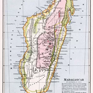
Mounted Print : Map of Madagascar by Jacques-Nicolas Bellin, 1766


![]()
Mounted Prints from Universal Images Group (UIG)
Map of Madagascar by Jacques-Nicolas Bellin, 1766
Cartography, 18th century. Map of Madagascar by Jacques-Nicolas Bellin, 1766
Universal Images Group (UIG) manages distribution for many leading specialist agencies worldwide
Media ID 9572269
© DEA / M. SEEMULLER
18th Century Island Madagascar Western Script Non Urban Scene
10"x8" Mount with 8"x6" Print
Step back in time with our exquisite Mounted Photos from Media Storehouse. This captivating piece features a beautifully detailed map of Madagascar, dating back to 1766. Created by renowned cartographer Jacques-Nicolas Bellin, this antique map is brought to life through our high-quality mounted photo. The intricate details of the coastlines, geographical features, and annotations are preserved in stunning clarity, making it a mesmerizing addition to any room. Travel back in time and explore the wonders of the 18th century with our Mounted Photo of the Map of Madagascar by Jacques-Nicolas Bellin, 1766, from Universal Images Group (UIG).
Printed on 8"x6" paper and suitable for use in a 10"x8" frame (frame not included). Prints are mounted with card both front and back. Featuring a custom cut aperture to match chosen image. Professional 234gsm Fujifilm Crystal Archive DP II paper.
Photo prints supplied in custom cut card mount ready for framing
Estimated Image Size (if not cropped) is 20.3cm x 13.9cm (8" x 5.5")
Estimated Product Size is 25.4cm x 20.3cm (10" x 8")
These are individually made so all sizes are approximate
Artwork printed orientated as per the preview above, with landscape (horizontal) orientation to match the source image.
EDITORS COMMENTS
This print showcases a historical gem - the Map of Madagascar by Jacques-Nicolas Bellin, dating back to 1766. The image transports us to the enchanting world of 18th-century cartography, where meticulous craftsmanship and artistry converged. In this studio shot, we are presented with a full-length view of the map, which beautifully captures the island's intricate landscape. The Map of Madagascar is an exquisite example of physical geography brought to life through Bellin's skilled hand. Its horizontal orientation allows us to immerse ourselves in every detail and contour that defines this remarkable landmass. As we explore its non-urban scene, devoid of any human presence, we can't help but marvel at the past it represents. Bellin's use of Western script adds another layer of intrigue as it guides our eyes across this masterpiece. The careful selection and placement of each element on the map demonstrate his expertise in both illustration and painting. This print from Universal Images Group (UIG) serves as a window into history, inviting us to appreciate not only the beauty but also the significance behind ancient maps like these. It reminds us that cartography was once an art form unto itself – one that allowed people to navigate uncharted territories and expand their understanding of our vast world
MADE IN THE UK
Safe Shipping with 30 Day Money Back Guarantee
FREE PERSONALISATION*
We are proud to offer a range of customisation features including Personalised Captions, Color Filters and Picture Zoom Tools
SECURE PAYMENTS
We happily accept a wide range of payment options so you can pay for the things you need in the way that is most convenient for you
* Options may vary by product and licensing agreement. Zoomed Pictures can be adjusted in the Basket.