Mounted Print > Architecture > Country > Turkey
Mounted Print : The Maghreb and the Middle East, Ottoman miniature


![]()
Mounted Prints from Universal Images Group (UIG)
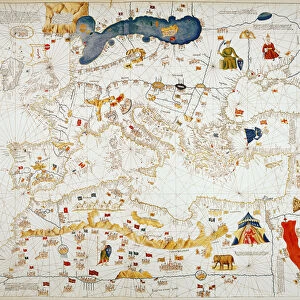
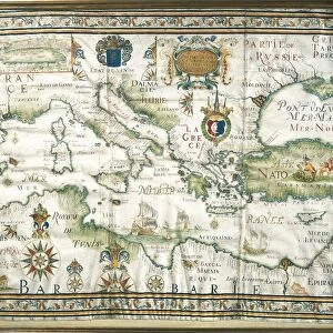
The Maghreb and the Middle East, Ottoman miniature
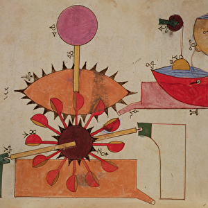
Cartography, late 16th century. The Maghreb and the Middle East. Ottoman miniature
Universal Images Group (UIG) manages distribution for many leading specialist agencies worldwide
Media ID 9502235
© DEA / G. DAGLI ORTI
16th Century Arabic Script Coastline Galata Maghreb Mediterranean Sea Miniature Ottoman Empire River Townscape Animal Representation Turkish Culture
10"x8" Mount with 8"x6" Print
Discover the rich history and culture of The Maghreb and the Middle East with our stunningly detailed Mounted Photos from Media Storehouse. This captivating image, sourced from the Universal Images Group (UIG), is an Ottoman miniature dating back to the late 16th century. The intricate cartography showcases the regions in exquisite detail, transporting you back in time. Add this beautiful piece to your home or office to inspire wanderlust and ignite conversations. Each Mounted Photo is meticulously printed on premium quality paper and mounted on a sturdy backing for a museum-quality finish. Experience the allure of the past with Media Storehouse.
Printed on 8"x6" paper and suitable for use in a 10"x8" frame (frame not included). Prints are mounted with card both front and back. Featuring a custom cut aperture to match chosen image. Professional 234gsm Fujifilm Crystal Archive DP II paper.
Photo prints supplied in custom cut card mount ready for framing
Estimated Image Size (if not cropped) is 20.3cm x 14.2cm (8" x 5.6")
Estimated Product Size is 25.4cm x 20.3cm (10" x 8")
These are individually made so all sizes are approximate
Artwork printed orientated as per the preview above, with landscape (horizontal) orientation to match the source image.
FEATURES IN THESE COLLECTIONS
> Architecture
> Country
> Turkey
> Architecture
> Styles
> Empire Architecture
> Architecture
> Styles
> Mediterranean Architecture
> Asia
> Turkey
> Related Images
> Maps and Charts
> Related Images
> Universal Images Group (UIG)
> Art
> Painting, Sculpture & Prints
> Cartography
EDITORS COMMENTS
This print showcases a remarkable Ottoman miniature from the late 16th century, depicting "The Maghreb and the Middle East". This exquisite piece of cartography art offers a fascinating glimpse into the intricate world of mapmaking during that era. The horizontal composition presents an expansive view of the Ottoman Empire, stretching across vast lands and encompassing diverse cultures. The Mediterranean Sea gracefully curves along the coastline, serving as a vital lifeline for trade and communication between nations. Intricate details bring this miniature to life, with townscape architecture meticulously depicted in vibrant colors. From bustling cities like Galata to serene rivers meandering through lush landscapes, every element is intricately portrayed. Arabic script adorns various parts of the map, adding an authentic touch to this masterpiece. It serves as a reminder of the rich cultural heritage and influence that Turkish culture had on this region during that time. Notably absent are human representations within this artwork; however, animal depictions add charm and character to certain areas. These artistic choices provide insight into both historical context and aesthetic preferences prevalent during Ottoman times. Overall, this stunning print captures not only geographical accuracy but also reflects the artistic prowess of its creator. It stands as a testament to how art intertwines with cartography in creating visually striking representations of our world's history.
MADE IN THE UK
Safe Shipping with 30 Day Money Back Guarantee
FREE PERSONALISATION*
We are proud to offer a range of customisation features including Personalised Captions, Color Filters and Picture Zoom Tools
SECURE PAYMENTS
We happily accept a wide range of payment options so you can pay for the things you need in the way that is most convenient for you
* Options may vary by product and licensing agreement. Zoomed Pictures can be adjusted in the Basket.