Mounted Print > North America > Canada > Lakes > Lake Erie
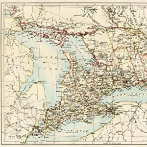
Mounted Print : Ontario, 1870s


![]()
Mounted Prints from North Wind
Ontario, 1870s
Map of Ontario, Canada, 1870s.
Printed color lithograph
North Wind Picture Archives brings history to life with stock images and hand-colored illustrations
Media ID 5879739
© North Wind Picture Archives
1870s Canada Canadian Great Lakes Lake Erie Lake Ontario Ontario Georgian Bay Lake Huron
10"x8" Mount with 8"x6" Print
Step back in time with our exquisite Mounted Photo from Media Storehouse, featuring a stunning printed color lithograph of Ontario, Canada from the 1870s. This captivating piece, sourced from the North Wind Picture Archives, showcases a detailed map of the province during a pivotal period in its history. Perfectly preserved and mounted on high-quality acid-free foam core, this vintage map makes an exceptional addition to any home or office decor. Transport yourself to a bygone era and relive the history of Ontario with this unique and intriguing piece.
Printed on 8"x6" paper and suitable for use in a 10"x8" frame (frame not included). Prints are mounted with card both front and back. Featuring a custom cut aperture to match chosen image. Professional 234gsm Fujifilm Crystal Archive DP II paper.
Photo prints supplied in custom cut card mount ready for framing
Estimated Image Size (if not cropped) is 20.3cm x 13.8cm (8" x 5.4")
Estimated Product Size is 25.4cm x 20.3cm (10" x 8")
These are individually made so all sizes are approximate
Artwork printed orientated as per the preview above, with landscape (horizontal) orientation to match the source image.
FEATURES IN THESE COLLECTIONS
> Asia
> Georgia
> Related Images
> Maps and Charts
> Related Images
> North America
> Canada
> Lakes
> Lake Erie
> North America
> Canada
> Lakes
> Lake Huron
> North America
> Canada
> Lakes
> Lake Ontario
> North America
> Canada
> Lakes
> Related Images
> North America
> Canada
> Maps
> North Wind Picture Archives
> Canadian history
> North Wind Picture Archives
> Maps
EDITORS COMMENTS
This vintage print takes us back to the 1870s, offering a captivating glimpse into the history of Ontario, Canada. The beautifully detailed map showcases the province's vast landscapes and waterways in stunning printed color lithograph. As we explore this piece of art, we are transported to a time when traditional heritage and historic illustrations were valued. The 19th-century illustration highlights Ontario's significant role in Canadian history. It depicts the region's expansive territory, stretching from Lake Erie to Georgian Bay and encompassing iconic landmarks such as Lake Ontario and Lake Huron. These Great Lakes served as vital transportation routes during that era, connecting communities across North America. As we delve deeper into this artwork, it becomes evident that it is more than just a map; it is an artistic representation of Ontario's natural beauty. The attention to detail captures the essence of the province's diverse geography - from rolling hills to dense forests - inviting viewers to appreciate its breathtaking scenery. This print not only serves as a historical artifact but also as a reminder of our connection with nature and our roots. It allows us to reflect on how much has changed since those early days while appreciating the timeless allure of Ontario’s landscape
MADE IN THE UK
Safe Shipping with 30 Day Money Back Guarantee
FREE PERSONALISATION*
We are proud to offer a range of customisation features including Personalised Captions, Color Filters and Picture Zoom Tools
SECURE PAYMENTS
We happily accept a wide range of payment options so you can pay for the things you need in the way that is most convenient for you
* Options may vary by product and licensing agreement. Zoomed Pictures can be adjusted in the Basket.