Mounted Print > Asia > Armenia > Maps
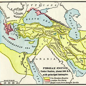
Mounted Print : Babylonia, Lydia, and Medea in ancient times


![]()
Mounted Prints from North Wind
Babylonia, Lydia, and Medea in ancient times
Map of ancient Babylonia and of the kingdoms of Lydia and Medea, circa 550 BC.
Printed color lithograph of a 19th-century illustration
North Wind Picture Archives brings history to life with stock images and hand-colored illustrations
Media ID 5878069
© North Wind Picture Archives
6th Century Bc Africa Ancient Ancient Civilization Ancient History Antiquity Arabia Asia Minor Babylon Babylonia Civilization Classical Classical Civilization Egypt Europe Mediterranean Sea Mesopotamia Mid East Middle East North Africa 500bc Armenia Lydia Medea Thrace
10"x8" Mount with 8"x6" Print
Step back in time with Media Storehouse's Mounted Photos featuring ancient civilizations. This captivating trio showcases Babylonia, Lydia, and Medea, as depicted in a 19th-century illustration from the North Wind Picture Archives. Witness the rich history and culture of these ancient kingdoms with this stunning, printed color lithograph. Perfect for adding a touch of history and intrigue to any room in your home or office. Each mounted photo is meticulously crafted for lasting beauty and durability.
Printed on 8"x6" paper and suitable for use in a 10"x8" frame (frame not included). Prints are mounted with card both front and back. Featuring a custom cut aperture to match chosen image. Professional 234gsm Fujifilm Crystal Archive DP II paper.
Photo prints supplied in custom cut card mount ready for framing
Estimated Image Size (if not cropped) is 20.3cm x 12.7cm (8" x 5")
Estimated Product Size is 25.4cm x 20.3cm (10" x 8")
These are individually made so all sizes are approximate
Artwork printed orientated as per the preview above, with landscape (horizontal) orientation to match the source image.
FEATURES IN THESE COLLECTIONS
> Africa
> Egypt
> Related Images
> Africa
> Related Images
> Asia
> Armenia
> Related Images
> Asia
> Related Images
> Europe
> Armenia
> Related Images
> Historic
> Ancient civilizations
> North Wind Picture Archives
> Ancient history
> North Wind Picture Archives
> Maps
EDITORS COMMENTS
This print takes us back in time to the ancient civilizations of Babylonia, Lydia, and Medea. Circa 550 BC, this map showcases the intricate details of these kingdoms that once thrived in the Middle East and beyond. The vibrant colors bring life to this 19th-century illustration, allowing us to envision how these lands may have appeared during their classical era. As we gaze upon this vintage artwork, we are transported to a world steeped in history and antiquity. From Mesopotamia's fertile plains to Lydia's rich cultural heritage, each region tells its own unique story within the tapestry of ancient civilization. The map not only highlights well-known territories like Babylon but also sheds light on lesser-known regions such as Thrace and Parthea. It serves as a visual reminder of how interconnected these societies were across Europe, Asia Minor, Africa, and Arabia. With the Mediterranean Sea acting as a gateway between continents, it is fascinating to see how trade routes would have crisscrossed through Babylonia and Lydia – connecting diverse cultures from Armenia to North Africa. This exquisite piece of art offers an opportunity for reflection on our shared human history while igniting curiosity about the lives lived by those who inhabited these lands over two millennia ago.
MADE IN THE UK
Safe Shipping with 30 Day Money Back Guarantee
FREE PERSONALISATION*
We are proud to offer a range of customisation features including Personalised Captions, Color Filters and Picture Zoom Tools
SECURE PAYMENTS
We happily accept a wide range of payment options so you can pay for the things you need in the way that is most convenient for you
* Options may vary by product and licensing agreement. Zoomed Pictures can be adjusted in the Basket.