Mounted Print > Maps and Charts > Turkey
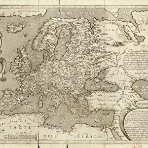
Mounted Print : Map / Europe / Balkans 1792


![]()
Mounted Prints from Mary Evans Picture Library
Map / Europe / Balkans 1792
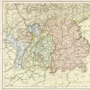
A map showing Turkey in Europe and its neighbouring European states of the Balkans
Mary Evans Picture Library makes available wonderful images created for people to enjoy over the centuries
Media ID 620825
© Mary Evans Picture Library 2015 - https://copyrighthub.org/s0/hub1/creation/maryevans/MaryEvansPictureID/10074527
1792 Balkans Maps Neighbouring
14"x12" Mount with 12"x10" Print
Step back in time with our exquisite Mounted Photos from Media Storehouse, featuring this captivating map of Europe and the Balkans from Mary Evans Prints Online. Dated 1792, this detailed illustration showcases the intriguing historical geography of the region, with Turkey prominently displayed in Europe and its neighboring European states of the Balkans. Add an air of sophistication and historical charm to your home or office with this beautifully mounted, ready-to-hang map print. A perfect addition to any room where history and geography intersect.
Printed on 12"x10" paper and suitable for use in a 14"x12" frame (frame not included). Prints are mounted with card both front and back. Featuring a custom cut aperture to match chosen image. Professional 234gsm Fujifilm Crystal Archive DP II paper.
Photo prints supplied in custom cut card mount ready for framing
Estimated Image Size (if not cropped) is 28.9cm x 25.4cm (11.4" x 10")
Estimated Product Size is 35.6cm x 30.5cm (14" x 12")
These are individually made so all sizes are approximate
Artwork printed orientated as per the preview above, with landscape (horizontal) orientation to match the source image.
FEATURES IN THESE COLLECTIONS
> Asia
> Turkey
> Related Images
> Europe
> Related Images
> Maps and Charts
> Early Maps
> Maps and Charts
> Related Images
EDITORS COMMENTS
This historical map print from 1792 showcases the intricate borders and political landscape of Europe, specifically focusing on the Balkans region and Turkey in Europe. The detailed cartography highlights the neighboring European states surrounding Turkey, providing a glimpse into the complex history and territorial divisions of the time.
The map offers a fascinating insight into the geopolitical dynamics of Europe during this period, with each country clearly delineated and labeled for easy reference. From Hungary to Greece, Serbia to Bulgaria, every nation is represented on this meticulously crafted piece of historical artwork.
As we study this map, we are transported back in time to an era when empires clashed and alliances shifted constantly. The intricate details and fine craftsmanship of the map serve as a testament to the skill and dedication of cartographers from centuries past.
Whether you are a history buff or simply appreciate fine artistry, this vintage map print is sure to captivate your imagination and spark curiosity about the rich tapestry of European history. Display it proudly in your home or office as a conversation piece that will inspire discussion about our shared past and how it has shaped our present-day world.
MADE IN THE UK
Safe Shipping with 30 Day Money Back Guarantee
FREE PERSONALISATION*
We are proud to offer a range of customisation features including Personalised Captions, Color Filters and Picture Zoom Tools
SECURE PAYMENTS
We happily accept a wide range of payment options so you can pay for the things you need in the way that is most convenient for you
* Options may vary by product and licensing agreement. Zoomed Pictures can be adjusted in the Basket.