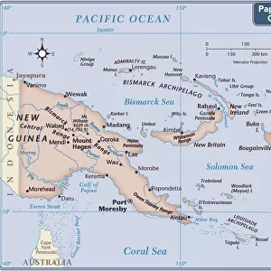
Mounted Print > Oceania > Papua New Guinea > Maps
Mounted Print : Map / East India Islands


![]()
Mounted Prints from Mary Evans Picture Library
Map / East India Islands
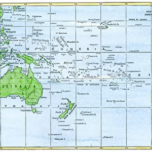
Map of the East India Islands, including Borneo, the Celebes, Sumatra, Papua New Guinea, the Philippines
Mary Evans Picture Library makes available wonderful images created for people to enjoy over the centuries
Media ID 608840
© Mary Evans Picture Library 2015 - https://copyrighthub.org/s0/hub1/creation/maryevans/MaryEvansPictureID/10114142
1864 Borneo Celebes Guinea Including Maps Papua Philippines Sumatra
10"x8" Mount with 8"x6" Print
Discover the rich history and geography of the East Indies with our stunningly detailed Map of the East India Islands from Mary Evans Picture Library. Part of our Media Storehouse Mounted Photos collection, this exquisite map showcases the East Indies in all its complexity, featuring intricate depictions of Borneo, the Celebes, Sumatra, Papua New Guinea, and the Philippines. Bring a touch of history and world exploration into your home or office with this beautifully preserved and mounted print, perfect for avid travelers, history enthusiasts, or anyone looking to add a unique and educational piece to their decor. Order now and let this captivating map transport you to a time of adventure and discovery.
Printed on 8"x6" paper and suitable for use in a 10"x8" frame (frame not included). Prints are mounted with card both front and back. Featuring a custom cut aperture to match chosen image. Professional 234gsm Fujifilm Crystal Archive DP II paper.
Photo prints supplied in custom cut card mount ready for framing
Estimated Image Size (if not cropped) is 19.8cm x 15.2cm (7.8" x 6")
Estimated Product Size is 25.4cm x 20.3cm (10" x 8")
These are individually made so all sizes are approximate
Artwork printed orientated as per the preview above, with landscape (horizontal) orientation to match the source image.
FEATURES IN THESE COLLECTIONS
> Asia
> India
> Related Images
> Asia
> Philippines
> Maps
> Asia
> Philippines
> Related Images
> Asia
> Related Images
> Maps and Charts
> Early Maps
> Maps and Charts
> India
> Maps and Charts
> Related Images
> Oceania
> Papua New Guinea
> Maps
EDITORS COMMENTS
This stunning vintage map print showcases the intricate details of the East India Islands, including Borneo, the Celebes, Sumatra, Papua New Guinea, and the Philippines. Dating back to 1864, this historical piece offers a glimpse into the past with its depiction of Asia's diverse geography.
The careful craftsmanship of this map is evident in its precise borders and labels, providing a comprehensive overview of these exotic islands. From the lush landscapes of Sumatra to the rugged terrain of Borneo, each island is uniquely represented on this artwork.
As you study this map closely, you can almost imagine embarking on a journey through these remote and mysterious lands. The rich history and cultural significance of each island come to life through this detailed illustration.
Whether you are a history buff or simply appreciate fine artistry, this Map of the East India Islands is sure to captivate your imagination. Display it proudly in your home or office as a conversation piece that will spark curiosity and admiration from all who see it.
Experience a piece of history with this remarkable print from Mary Evans Picture Library - a true treasure for any collector or enthusiast.
MADE IN THE UK
Safe Shipping with 30 Day Money Back Guarantee
FREE PERSONALISATION*
We are proud to offer a range of customisation features including Personalised Captions, Color Filters and Picture Zoom Tools
SECURE PAYMENTS
We happily accept a wide range of payment options so you can pay for the things you need in the way that is most convenient for you
* Options may vary by product and licensing agreement. Zoomed Pictures can be adjusted in the Basket.