Mounted Print > Europe > France > Canton > Landes
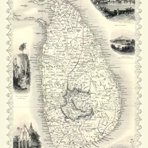
Mounted Print : Map of Ceylon showing tea industry plantations


![]()
Mounted Prints from Mary Evans Picture Library
Map of Ceylon showing tea industry plantations
Map of Ceylon (Sri Lanka) showing tea industry plantations. Date: circa 1920
Mary Evans Picture Library makes available wonderful images created for people to enjoy over the centuries
Media ID 14410278
© Mary Evans / Pharcide
Ceylon Growing Lanka Plantation Plantations Sunshine
10"x8" Mount with 8"x6" Print
Add a touch of history and elegance to your home or office with our exquisite Mounted Photos from the Media Storehouse range. This particular piece features a captivating map of Ceylon (now Sri Lanka) from circa 1920, showcasing the extensive tea industry plantations. Rights Managed through Mary Evans Prints Online, this vintage map is not only a beautiful decorative piece but also a fascinating insight into the rich history of tea production in Sri Lanka. Bring the charm of the past into your present with our high-quality mounted prints.
Printed on 8"x6" paper and suitable for use in a 10"x8" frame (frame not included). Prints are mounted with card both front and back. Featuring a custom cut aperture to match chosen image. Professional 234gsm Fujifilm Crystal Archive DP II paper.
Photo prints supplied in custom cut card mount ready for framing
Estimated Image Size (if not cropped) is 13.2cm x 20.3cm (5.2" x 8")
Estimated Product Size is 20.3cm x 25.4cm (8" x 10")
These are individually made so all sizes are approximate
Artwork printed orientated as per the preview above, with portrait (vertical) orientation to match the source image.
FEATURES IN THESE COLLECTIONS
> Asia
> India
> Related Images
> Asia
> Sri Lanka
> Related Images
> Europe
> France
> Canton
> Landes
> Maps and Charts
> British Empire Maps
> Maps and Charts
> India
> Maps and Charts
> Related Images
EDITORS COMMENTS
1. Title: "Map of Ceylon (Sri Lanka) in the 1920s: A Visual Testament to the British Tea Industry's Colonial Expansion" This map print, dated circa 1920, offers a glimpse into the British colonial influence on Ceylon (now Sri Lanka) during the 1920s, with a focus on the burgeoning tea industry. The map, bathed in a warm, sunlit hue, beautifully illustrates the island nation's geography, with its intricate network of tea plantations spread across the lush, green highlands. The map's vibrant colors – a rich tapestry of blue seas, sun-kissed land, and the verdant greens of the tea plantations – evoke a sense of tranquility and prosperity. The island's strategic location in the Indian Ocean, marked by the presence of ships and shipping lanes, underscores its importance as a vital trading hub during the colonial era. The British Empire's influence is evident in the map's meticulous detailing, with the tea plantations neatly demarcated and labeled, showcasing the extensive reach of the tea industry. The map serves as a testament to the British colonial endeavor in Ceylon, which transformed the island into a major global tea producer. The map's visual appeal extends beyond its historical significance, making it an intriguing addition to any collection focused on colonial history, geography, or the tea industry. Its evocative imagery of sunshine, sea, land, and the promise of a cup of fine Ceylon tea, continues to resonate with us today, offering a glimpse into a bygone era.
MADE IN THE UK
Safe Shipping with 30 Day Money Back Guarantee
FREE PERSONALISATION*
We are proud to offer a range of customisation features including Personalised Captions, Color Filters and Picture Zoom Tools
SECURE PAYMENTS
We happily accept a wide range of payment options so you can pay for the things you need in the way that is most convenient for you
* Options may vary by product and licensing agreement. Zoomed Pictures can be adjusted in the Basket.