Mounted Print > Maps and Charts > Related Images
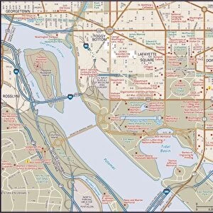
Mounted Print : Washington DC City Map


![]()
Mounted Prints from Map Marketing
Washington DC City Map
A street level map of central Washington D.C. based on USGS topo map data. Covers from Manor Park in the north to Washington Highlands in the south and from Dupont Park in the east to Fort Myer in the west
Media ID 19951152
© Map Marketing Ltd, Map Data courtesy of USGS
10"x8" Mount with 8"x6" Print
Printed on 8"x6" paper and suitable for use in a 10"x8" frame (frame not included). Prints are mounted with card both front and back. Featuring a custom cut aperture to match chosen image. Professional 234gsm Fujifilm Crystal Archive DP II paper.
Photo prints supplied in custom cut card mount ready for framing
Estimated Image Size (if not cropped) is 15.2cm x 20cm (6" x 7.9")
Estimated Product Size is 20.3cm x 25.4cm (8" x 10")
These are individually made so all sizes are approximate
Artwork printed orientated as per the preview above, with portrait (vertical) orientation to match the source image.
FEATURES IN THESE COLLECTIONS
> Europe
> United Kingdom
> Scotland
> Highlands
> Related Images
> Maps and Charts
> Related Images
MADE IN THE UK
Safe Shipping with 30 Day Money Back Guarantee
FREE PERSONALISATION*
We are proud to offer a range of customisation features including Personalised Captions, Color Filters and Picture Zoom Tools
SECURE PAYMENTS
We happily accept a wide range of payment options so you can pay for the things you need in the way that is most convenient for you
* Options may vary by product and licensing agreement. Zoomed Pictures can be adjusted in the Basket.