Mounted Print > Arts > Artists > S > Petrus Schenk
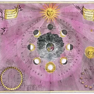
Mounted Print : Map Circuli Franconiae pars orientalis et potior novisimí delineat


![]()
Mounted Prints from Liszt Collection
Map Circuli Franconiae pars orientalis et potior novisimí delineat
Map, Circuli Franconiae pars orientalis et potior noviszime delineata, Petrus Schenk (1693-1775), Copperplate print
Liszt Collection of nineteenth-century engravings and images to browse and enjoy
Media ID 19585874
© Artokoloro
1693 1775 Copperplate Print Petrus Schenk
10"x8" Mount with 8"x6" Print
Introducing the Media Storehouse Mounted Photos featuring the exquisite Map Circuli Franconiae pars orientalis et potior novisimia delineata from the renowned Liszt Collection. This stunning copperplate print, created by Petrus Schenk in 1775, showcases an intricately detailed map of the eastern part of Franconia, a historical region in present-day Germany. Each mounted photo is meticulously crafted to preserve the rich colors and fine lines of the original map, making it a captivating addition to any home or office. Immerse yourself in the beauty of historical cartography with our high-quality, museum-grade mounted photos.
Printed on 8"x6" paper and suitable for use in a 10"x8" frame (frame not included). Prints are mounted with card both front and back. Featuring a custom cut aperture to match chosen image. Professional 234gsm Fujifilm Crystal Archive DP II paper.
Photo prints supplied in custom cut card mount ready for framing
Estimated Image Size (if not cropped) is 15.2cm x 18.1cm (6" x 7.1")
Estimated Product Size is 20.3cm x 25.4cm (8" x 10")
These are individually made so all sizes are approximate
Artwork printed orientated as per the preview above, with portrait (vertical) orientation to match the source image.
FEATURES IN THESE COLLECTIONS
> Animals
> Mammals
> Cricetidae
> Orientalis
> Arts
> Artists
> S
> Petrus Schenk
> Maps and Charts
> Related Images
EDITORS COMMENTS
This print from the Liszt Collection showcases a beautifully detailed map titled "Map, Circuli Franconiae pars orientalis et potior novisimí delineat". Created by the talented cartographer Petrus Schenk (1693-1775), this copperplate print is a true masterpiece of its time. The map depicts the eastern part of Circuli Franconiae, offering a glimpse into the region's intricate geography. Every contour and boundary line has been meticulously drawn with precision and artistry, showcasing Schenk's exceptional skill in cartography. The delicate details on this copperplate print are truly awe-inspiring, capturing both historical accuracy and aesthetic beauty. As you explore this remarkable piece, you can't help but be transported back to an era when maps were not only tools for navigation but also works of art. The fine lines and intricate patterns invite you to immerse yourself in the rich history of Franconiae. From its rolling hills to its winding rivers, every feature on this map tells a story waiting to be discovered. Whether you're an avid collector or simply appreciate the beauty of antique prints, this print is sure to captivate your imagination. It serves as a testament to Schenk's talent as well as his dedication to preserving geographical knowledge through his exquisite craftsmanship
MADE IN THE UK
Safe Shipping with 30 Day Money Back Guarantee
FREE PERSONALISATION*
We are proud to offer a range of customisation features including Personalised Captions, Color Filters and Picture Zoom Tools
SECURE PAYMENTS
We happily accept a wide range of payment options so you can pay for the things you need in the way that is most convenient for you
* Options may vary by product and licensing agreement. Zoomed Pictures can be adjusted in the Basket.