Mounted Print > Arts > Minimalist artwork > Monochrome artwork > Fine art
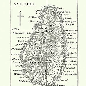
Mounted Print : A map of St Lucia, the West Indies, 1758. Artist: N Bellun


![]()
Mounted Prints from Heritage Images
A map of St Lucia, the West Indies, 1758. Artist: N Bellun
A map of St Lucia, the West Indies, 1758
Heritage Images features heritage image collections
Media ID 14936008
© The Print Collector / Heritage-Images
Caribbean Copperplate Gulf Gulf Of Mexico Indies Island Lesser Antilles Saint Lucia St Lucia West Indian West Indies Windward Islands
10"x8" Mount with 8"x6" Print
Step back in time with our exquisite Mounted Photos from Media Storehouse. This captivating piece features an authentic 1758 map of St Lucia in the West Indies, skillfully crafted by N Bellun from Heritage Images. Delve into the rich history of this beautiful island with intricate details and accurate depictions of the region as it once was. Add an air of sophistication and historical charm to your home or office decor with this stunning, museum-quality mounted map. Travel back in time and explore the wonders of the past, all while adding a unique touch to your space.
Printed on 8"x6" paper and suitable for use in a 10"x8" frame (frame not included). Prints are mounted with card both front and back. Featuring a custom cut aperture to match chosen image. Professional 234gsm Fujifilm Crystal Archive DP II paper.
Photo prints supplied in custom cut card mount ready for framing
Estimated Image Size (if not cropped) is 20.3cm x 13.4cm (8" x 5.3")
Estimated Product Size is 25.4cm x 20.3cm (10" x 8")
These are individually made so all sizes are approximate
Artwork printed orientated as per the preview above, with landscape (horizontal) orientation to match the source image.
FEATURES IN THESE COLLECTIONS
> Arts
> Artists
> Related Images
> Arts
> Minimalist artwork
> Monochrome artwork
> Fine art
> Arts
> Minimalist artwork
> Monochrome artwork
> Monochrome paintings
> Maps and Charts
> Related Images
> North America
> Mexico
> Maps
> North America
> Mexico
> Related Images
> North America
> Saint Lucia
> Maps
> North America
> Saint Lucia
> Related Images
EDITORS COMMENTS
This print takes us back in time to the year 1758, showcasing a meticulously detailed map of St Lucia, one of the enchanting islands nestled in the West Indies. Created by the talented artist N Bellun, this copperplate engraving offers a glimpse into the geographical features that define this Caribbean gem. The map highlights St Lucia's strategic location within the West Indies, situated amidst the azure waters of the Gulf of Mexico. Its inclusion among the Lesser Antilles and Windward Islands further emphasizes its significance in regional geography. Every contour and coastline is intricately etched on this monochrome masterpiece, allowing viewers to appreciate both its artistic beauty and informative value. As we explore this historic cartographic treasure, it becomes evident that N Bellun possessed an exceptional skill for capturing intricate details with precision. The print transports us to an era when maps were not only functional tools but also works of art. Whether you are a history enthusiast or simply captivated by St Lucia's allure, this print serves as a visual gateway to immerse yourself in its rich past. Let your imagination wander through time as you trace each line on this exquisite piece from Heritage Images' collection - a testament to N Bellun's talent and dedication to preserving our world's geographic heritage.
MADE IN THE UK
Safe Shipping with 30 Day Money Back Guarantee
FREE PERSONALISATION*
We are proud to offer a range of customisation features including Personalised Captions, Color Filters and Picture Zoom Tools
SECURE PAYMENTS
We happily accept a wide range of payment options so you can pay for the things you need in the way that is most convenient for you
* Options may vary by product and licensing agreement. Zoomed Pictures can be adjusted in the Basket.