Mounted Print > Europe > United Kingdom > Scotland > Edinburgh > Edinburgh
Mounted Print : Map of the Barbary States, 1902. Creator: Unknown


![]()
Mounted Prints from Heritage Images
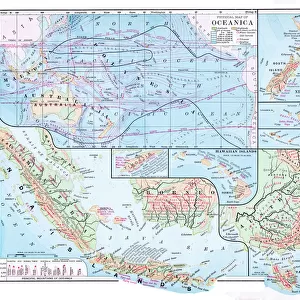
Map of the Barbary States, 1902. Creator: Unknown
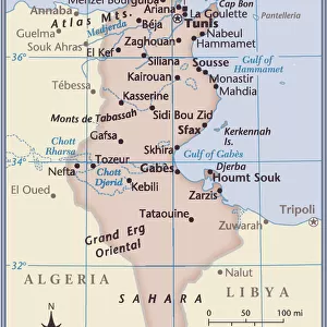
Map of the Barbary States, 1902. Showing Morocco, Algeria, Tunisia, and Libya on the North African coast, with inset of Gibraltar. From The Century Atlas of the World. [John Walker & Co, Ltd. London, 1902]
Heritage Images features heritage image collections
Media ID 15512426
© The Print Collector / Heritage-Images
Algeria Coastline Edinburgh Geographical Institute Libya Mediterranean Sea Morocco North Africa Tunisia Barbary Coast
10"x8" Mount with 8"x6" Print
Discover the rich history of North Africa with our stunning Mounted Photo of the Barbary States Map from 1902. This captivating vintage map, sourced from The Century Atlas of the World, showcases the Barbary States, including Morocco, Algeria, Tunisia, and Libya, as they appeared over a century ago. With intricate detail and an inset of Gibraltar, this mounted photo is a perfect addition to any home or office, transporting you back in time. Created by an unknown artist from Heritage Images, this map is not only a beautiful piece of decor but also a fascinating historical artifact. Bring a touch of the past into your space with our Mounted Photo of the Barbary States Map.
Printed on 8"x6" paper and suitable for use in a 10"x8" frame (frame not included). Prints are mounted with card both front and back. Featuring a custom cut aperture to match chosen image. Professional 234gsm Fujifilm Crystal Archive DP II paper.
Photo prints supplied in custom cut card mount ready for framing
Estimated Image Size (if not cropped) is 20.3cm x 14.4cm (8" x 5.7")
Estimated Product Size is 25.4cm x 20.3cm (10" x 8")
These are individually made so all sizes are approximate
Artwork printed orientated as per the preview above, with landscape (horizontal) orientation to match the source image.
FEATURES IN THESE COLLECTIONS
> Africa
> Algeria
> Related Images
> Africa
> Libya
> Related Images
> Africa
> Morocco
> Related Images
> Africa
> Tunisia
> Related Images
> Europe
> United Kingdom
> Scotland
> Edinburgh
> Edinburgh
> Europe
> United Kingdom
> Scotland
> Lothian
> Edinburgh
EDITORS COMMENTS
This print showcases a Map of the Barbary States, created in 1902 by an unknown artist. The map provides a detailed representation of Morocco, Algeria, Tunisia, and Libya along the North African coast. It also includes an inset of Gibraltar, adding to its historical significance. The vibrant colors used in this print bring life to the continent and highlight the diverse landscapes found within these regions. Created during the early 20th century, this map offers valuable insights into Africa's geographical features and political boundaries at that time. The Edinburgh Geographical Institute is credited for producing this remarkable piece which was featured in The Century Atlas of the World published by John Walker & Co. , Ltd. , London in 1902. Its inclusion in such a prestigious publication further emphasizes its importance as a reliable source for geographic information. Preserved by The Print Collector, this image captures not only the beauty but also serves as a testament to our ever-evolving understanding of global geography. As we explore this map today, it allows us to appreciate how much has changed over time while providing context for historical events that shaped these nations.
MADE IN THE UK
Safe Shipping with 30 Day Money Back Guarantee
FREE PERSONALISATION*
We are proud to offer a range of customisation features including Personalised Captions, Color Filters and Picture Zoom Tools
SECURE PAYMENTS
We happily accept a wide range of payment options so you can pay for the things you need in the way that is most convenient for you
* Options may vary by product and licensing agreement. Zoomed Pictures can be adjusted in the Basket.