Mounted Print > North America > United States of America > Massachusetts > Boston
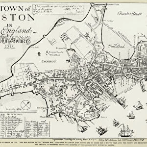
Mounted Print : BOSTON MAP, 1722. A map of Boston, Massachusetts, by John Bonner. Line engraving, 1722


![]()
Mounted Prints from Granger
BOSTON MAP, 1722. A map of Boston, Massachusetts, by John Bonner. Line engraving, 1722
Granger holds millions of images spanning more than 25,000 years of world history, from before the Stone Age to the dawn of the Space Age
Media ID 7520673
1722 Bonner Boston Colony Topography
10"x8" Mount with 8"x6" Print
Step back in time with our exquisite BOSTON MAP, 1722. This stunning, vintage representation of Boston, Massachusetts, is a captivating piece of history brought to life. Meticulously crafted by John Bonner in 1722, this line engraving from The Granger Collection is a testament to the rich history of America's oldest city. Add a touch of timeless charm to your home or office with this beautifully preserved piece of cartography from the past. Order your BOSTON MAP, 1722, today and let history come alive in your space.
Printed on 8"x6" paper and suitable for use in a 10"x8" frame (frame not included). Prints are mounted with card both front and back. Featuring a custom cut aperture to match chosen image. Professional 234gsm Fujifilm Crystal Archive DP II paper.
Photo prints supplied in custom cut card mount ready for framing
Estimated Image Size (if not cropped) is 20.3cm x 15cm (8" x 5.9")
Estimated Product Size is 25.4cm x 20.3cm (10" x 8")
These are individually made so all sizes are approximate
Artwork printed orientated as per the preview above, with landscape (horizontal) orientation to match the source image.
FEATURES IN THESE COLLECTIONS
> Maps and Charts
> Related Images
> North America
> United States of America
> Massachusetts
> Boston
EDITORS COMMENTS
This print showcases a historical treasure, the "BOSTON MAP, 1722" meticulously crafted by John Bonner. Dating back to the early days of America's formation, this line engraving offers a fascinating glimpse into the topography and layout of Boston, Massachusetts in the year 1722. With intricate details and precision, Bonner's map captures the essence of colonial Boston. It highlights key landmarks such as North River and provides an accurate depiction of the city's streets and neighborhoods during that time period. As we gaze upon this piece, we are transported back to an era when Boston was still evolving as a bustling American colony. The artistry behind this engraving is truly remarkable. Each stroke on paper tells a story of exploration and discovery in early New England history. The careful attention given to every street corner and building reflects both Bonner's dedication as an artist and his commitment to accurately representing his beloved city. As admirers of art and history alike, we can't help but appreciate how this print from The Granger Collection allows us to connect with our past. It serves as a reminder that beneath modern skyscrapers lie centuries-old foundations that have shaped our present-day metropolis. Whether you're a lover of maps or simply intrigued by American history, this stunning print will undoubtedly spark curiosity about Boston's rich heritage while adding elegance to any space it graces.
MADE IN THE UK
Safe Shipping with 30 Day Money Back Guarantee
FREE PERSONALISATION*
We are proud to offer a range of customisation features including Personalised Captions, Color Filters and Picture Zoom Tools
SECURE PAYMENTS
We happily accept a wide range of payment options so you can pay for the things you need in the way that is most convenient for you
* Options may vary by product and licensing agreement. Zoomed Pictures can be adjusted in the Basket.