Mounted Print > Europe > United Kingdom > England > London > Sights > Tower of London
Mounted Print : Great Fire Map


![]()
Mounted Prints from Fine Art Storehouse
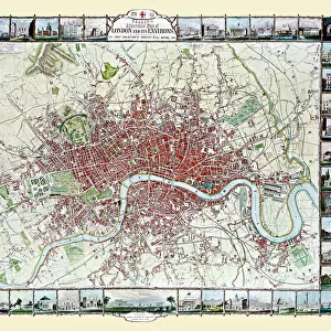
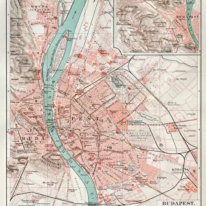
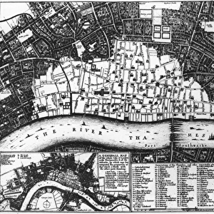
Great Fire Map
A map of the City of London by Wenceslas Hollar, with the light area north of the Thames showing the extent of the area destroyed in the Great Fire of London, 1666. The Tower of London can be seen centre, right. (Photo by Hulton Archive/Getty Images)
Unleash your creativity and transform your space into a visual masterpiece!
Hulton Archive
Media ID 11795930
© 2008 Getty Images
10"x8" Mount with 8"x6" Print
Discover the rich history of the Great Fire of London with our stunning Mounted Photos from Media Storehouse's Fine Art Storehouse. This captivating piece features an iconic map by Wenceslas Hollar, depicting the City of London after the devastating fire of 1666. The intricate details of the map are brought to life with our high-quality mounting, creating a beautiful and historic addition to any room. Relive the past and add a touch of history to your home or office with this unique and captivating piece.
Printed on 8"x6" paper and suitable for use in a 10"x8" frame (frame not included). Prints are mounted with card both front and back. Featuring a custom cut aperture to match chosen image. Professional 234gsm Fujifilm Crystal Archive DP II paper.
Photo prints supplied in custom cut card mount ready for framing
Estimated Image Size (if not cropped) is 19cm x 15.2cm (7.5" x 6")
Estimated Product Size is 25.4cm x 20.3cm (10" x 8")
These are individually made so all sizes are approximate
Artwork printed orientated as per the preview above, with landscape (horizontal) orientation to match the source image.
FEATURES IN THESE COLLECTIONS
> Fine Art Storehouse
> History
> Great Fire of London (2-5 September)
> Fine Art Storehouse
> Photo Libraries
> Heritage Images
> Architecture
> Towers
> Tower of London
> Arts
> Artists
> H
> Wenceslas Hollar
> Europe
> United Kingdom
> England
> London
> Boroughs
> City of London
> Europe
> United Kingdom
> England
> London
> River Thames
> Europe
> United Kingdom
> England
> London
> Sights
> Tower of London
> Maps and Charts
> Related Images
> Popular Themes
> Tower of London
EDITORS COMMENTS
This print showcases the Great Fire Map, a historical artifact that vividly depicts the devastating impact of the Great Fire of London in 1666. Created by Wenceslas Hollar, this meticulously detailed map reveals the extent of destruction caused by the fire, with the light area north of the Thames representing the ravaged cityscape. The iconic Tower of London stands prominently at the center-right, serving as a poignant reminder of both resilience and loss. The image transports us back to an early date in history when London was still recovering from one of its most catastrophic events. With no signs of human presence captured within this snapshot, it allows us to focus solely on understanding and appreciating this significant moment in time. Rendered in striking black and white tones, every intricate detail is brought to life - from street names to architectural landmarks - painting a haunting picture of a city forever changed. As we explore this historic map through our eyes, we are transported into an era long gone but not forgotten. This remarkable print serves as a testament to London's rich history and reminds us how even amidst great tragedy, cities can rise again from their ashes. It is an invaluable piece for any history enthusiast or lover of fine art who wishes to delve deeper into London's past and witness firsthand its enduring spirit.
MADE IN THE UK
Safe Shipping with 30 Day Money Back Guarantee
FREE PERSONALISATION*
We are proud to offer a range of customisation features including Personalised Captions, Color Filters and Picture Zoom Tools
SECURE PAYMENTS
We happily accept a wide range of payment options so you can pay for the things you need in the way that is most convenient for you
* Options may vary by product and licensing agreement. Zoomed Pictures can be adjusted in the Basket.