Mounted Print > North America > United States of America > Kentucky > Louisville
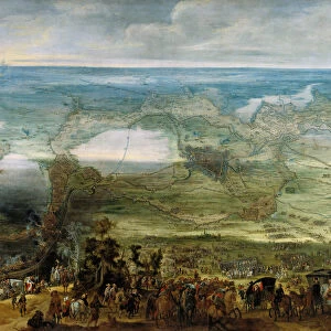
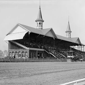
Mounted Print : Old map of the Ohio River between Indiana and Kentucky


![]()
Mounted Prints from Fine Art Storehouse
Old map of the Ohio River between Indiana and Kentucky
Old map of the Ohio River between Indiana and Kentucky - Scanned 1887 map
Unleash your creativity and transform your space into a visual masterpiece!
benoitb
Media ID 14719307
© This content is subject to copyright
Geography Indiana Kentucky Ohio River Sketch Washington Classical Style Louisville Us State Victorian Style
10"x8" Mount with 8"x6" Print
Step back in time with our Old Map of the Ohio River between Indiana and Kentucky from the Fine Art Storehouse, part of the Media Storehouse range. This exquisite, scanned 1887 map by benoitb transports you to an era of exploration and discovery. The intricate details of the map showcase the historical geography of the region, making it a captivating addition to any home or office. Bring a touch of history into your space and ignite curiosity with this beautiful, mounted vintage map.
Printed on 8"x6" paper and suitable for use in a 10"x8" frame (frame not included). Prints are mounted with card both front and back. Featuring a custom cut aperture to match chosen image. Professional 234gsm Fujifilm Crystal Archive DP II paper.
Photo prints supplied in custom cut card mount ready for framing
Estimated Image Size (if not cropped) is 20.3cm x 8.8cm (8" x 3.5")
Estimated Product Size is 25.4cm x 20.3cm (10" x 8")
These are individually made so all sizes are approximate
Artwork printed orientated as per the preview above, with landscape (horizontal) orientation to match the source image.
FEATURES IN THESE COLLECTIONS
> Fine Art Storehouse
> Map
> Historical Maps
> Fine Art Storehouse
> Map
> USA Maps
> Arts
> Landscape paintings
> Waterfall and river artworks
> River artworks
> Maps and Charts
> Related Images
> North America
> United States of America
> Indiana
> Related Images
> North America
> United States of America
> Kentucky
> Louisville
> North America
> United States of America
> Kentucky
> Related Images
> North America
> United States of America
> Maps
> North America
> United States of America
> Ohio
> Related Images
> North America
> United States of America
> Washington
> Related Images
EDITORS COMMENTS
This print takes us on a journey back in time to the late 19th century, as we explore an old map of the Ohio River between Indiana and Kentucky. Scanned from an authentic 1887 map, this piece of art showcases the intricate details and craftsmanship of Victorian-style engraving. The artist, Benoitb, has beautifully captured the essence of history through this antique illustration. The classical style adds a touch of elegance to the depiction, making it a perfect addition to any vintage or historical collection. As our eyes wander across the print, we can't help but be drawn into its rich geography. From Washington to Louisville, every town along the river is meticulously labeled – reminding us of their significance during that era. The Ohio River itself takes center stage with its meandering curves and flowing currents. This engraved image not only serves as a stunning decorative piece but also offers us a glimpse into America's past. It evokes feelings of nostalgia for simpler times when maps were carefully crafted by hand and exploration was filled with wonder. Whether you are an avid collector or simply appreciate art that tells stories from yesteryears, this old map print will transport you back in time while adding a touch of sophistication to your space.
MADE IN THE UK
Safe Shipping with 30 Day Money Back Guarantee
FREE PERSONALISATION*
We are proud to offer a range of customisation features including Personalised Captions, Color Filters and Picture Zoom Tools
SECURE PAYMENTS
We happily accept a wide range of payment options so you can pay for the things you need in the way that is most convenient for you
* Options may vary by product and licensing agreement. Zoomed Pictures can be adjusted in the Basket.