Mounted Print > Africa > Botswana > Maps
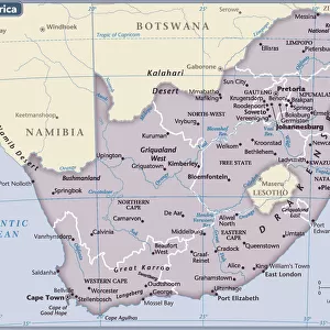
Mounted Print : Reference Map of Map of South Africa


![]()
Mounted Prints from Fine Art Storehouse
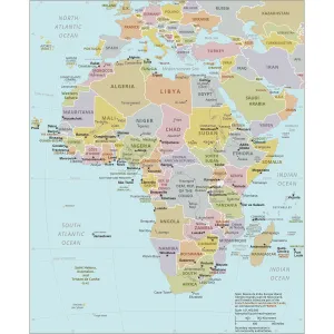
Reference Map of Map of South Africa
South Africa is located in southern Africa. South Africa is bordered by the Atlantic Ocean and the Indian Ocean, Lesotho and eSwatini (formerly Swaziland) in the eastern portion of South Africa, and Namibia, Botswana, Zimbabwe, and Mozambique to the north
Unleash your creativity and transform your space into a visual masterpiece!
Media ID 20251055
14"x12" Mount with 12"x10" Print
Discover the beauty and rich history of South Africa with our exquisite Mounted Photos from Media Storehouse's Fine Art Storehouse. This stunning Reference Map of South Africa is meticulously captured in high-resolution detail, showcasing the diverse landscapes, borders with the Atlantic and Indian Oceans, and neighboring countries of Lesotho and eSwatini. Each Mounted Photo is carefully crafted with premium materials, ensuring a lasting impression. Bring a piece of Africa into your home or office and elevate your decor with this unique and captivating addition.
Printed on 12"x10" paper and suitable for use in a 14"x12" frame (frame not included). Prints are mounted with card both front and back. Featuring a custom cut aperture to match chosen image. Professional 234gsm Fujifilm Crystal Archive DP II paper.
Photo prints supplied in custom cut card mount ready for framing
Estimated Image Size (if not cropped) is 25.4cm x 25.9cm (10" x 10.2")
Estimated Product Size is 30.5cm x 35.6cm (12" x 14")
These are individually made so all sizes are approximate
Artwork printed orientated as per the preview above, with portrait (vertical) orientation to match the source image.
FEATURES IN THESE COLLECTIONS
> Africa
> Botswana
> Related Images
> Africa
> Lesotho
> Related Images
> Africa
> Mozambique
> Maps
> Africa
> Mozambique
> Related Images
> Africa
> Namibia
> Related Images
> Africa
> Related Images
> Africa
> South Africa
> Maps
EDITORS COMMENTS
This print showcases a meticulously detailed reference map of South Africa, offering a comprehensive glimpse into the diverse landscapes and geographical features that define this remarkable country. Located in southern Africa, South Africa is bordered by both the Atlantic Ocean and the Indian Ocean, creating an awe-inspiring coastline that stretches for miles on end. The map highlights not only the country's extensive shoreline but also its neighboring countries. To the east, Lesotho and eSwatini (formerly Swaziland) form a natural boundary with South Africa, while to the north lie Namibia, Botswana, Zimbabwe, and Mozambique. These nations contribute to South Africa's rich cultural tapestry through shared histories and influences. Every inch of this artful depiction has been thoughtfully crafted to showcase topographical details such as mountain ranges, rivers, lakes, and national parks. It invites viewers to embark on a visual journey across vast plains dotted with vibrant cities like Johannesburg or Cape Town; traverse breathtaking mountainous regions such as Drakensberg; or explore iconic landmarks like Kruger National Park. Whether you are an avid traveler seeking inspiration for your next adventure or simply intrigued by cartography's beauty and precision—this exquisite print from Fine Art Storehouse is sure to captivate your imagination. Its intricate details will transport you directly into South Africa's enchanting world without ever leaving your home.
MADE IN THE UK
Safe Shipping with 30 Day Money Back Guarantee
FREE PERSONALISATION*
We are proud to offer a range of customisation features including Personalised Captions, Color Filters and Picture Zoom Tools
SECURE PAYMENTS
We happily accept a wide range of payment options so you can pay for the things you need in the way that is most convenient for you
* Options may vary by product and licensing agreement. Zoomed Pictures can be adjusted in the Basket.