Mounted Print > North America > United States of America > New York > New York > Maps
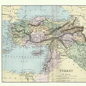
Mounted Print : Map of Turkey and Greece 1894


![]()
Mounted Prints from Fine Art Storehouse
Map of Turkey and Greece 1894
Johnsons Universal Cyclopedia - Volume VIII New York - A. J. Johnson Company 1894
Unleash your creativity and transform your space into a visual masterpiece!
THEPALMER
Media ID 18356777
10"x8" Mount with 8"x6" Print
Step back in time with our exquisite Mounted Photo from Media Storehouse's Fine Art Storehouse collection. This captivating piece features a detailed Map of Turkey and Greece, as it appeared in Johnsons Universal Cyclopedia - Volume VIII published by A. J. Johnson Company in 1894. The Map, titled "THEPALMER," showcases the historical geography of the region during this era. Each Mounted Photo is meticulously printed on high-quality archival paper and mounted on a sturdy, acid-free backing, ensuring longevity and preservation. Add an air of vintage elegance and historical intrigue to your home or office decor with this unique and authentic piece from Media Storehouse's Fine Art Storehouse collection.
Printed on 8"x6" paper and suitable for use in a 10"x8" frame (frame not included). Prints are mounted with card both front and back. Featuring a custom cut aperture to match chosen image. Professional 234gsm Fujifilm Crystal Archive DP II paper.
Photo prints supplied in custom cut card mount ready for framing
Estimated Image Size (if not cropped) is 18.2cm x 15.2cm (7.2" x 6")
Estimated Product Size is 25.4cm x 20.3cm (10" x 8")
These are individually made so all sizes are approximate
Artwork printed orientated as per the preview above, with landscape (horizontal) orientation to match the source image.
FEATURES IN THESE COLLECTIONS
> Fine Art Storehouse
> Map
> Historical Maps
> Asia
> Turkey
> Related Images
> Europe
> Greece
> Related Images
> Historic
> Ancient civilizations
> Ancient Greece
> Greek history
> Maps and Charts
> Related Images
> North America
> United States of America
> New York
> New York
> Maps
> North America
> United States of America
> New York
> Related Images
EDITORS COMMENTS
In this print titled "Map of Turkey and Greece 1894" we are transported back in time to the late 19th century. This historical map, sourced from Johnsons Universal Cyclopedia - Volume VIII New York, takes us on a journey through the intricate borders and rich cultural heritage of Turkey and Greece. The meticulous detail captured in this print allows us to explore the diverse landscapes that make up these two fascinating countries. From the rugged mountain ranges to the winding coastlines along the Aegean Sea, every contour is beautifully depicted with precision. As we study this vintage map, we can't help but marvel at how much has changed since its creation over a century ago. It serves as a reminder of how political boundaries have shifted and evolved throughout history. The names of cities and regions may have altered, but their significance remains intact. "The Map of Turkey and Greece 1894" invites us to reflect upon our shared human history while also appreciating the artistry behind cartography. Its aged appearance adds an extra layer of charm, reminding us that it is not just a mere representation but also an artifact from another era. Whether you're an avid historian or simply captivated by old-world aesthetics, this print by THEPALMER offers both educational value and artistic appeal. It serves as a timeless piece that sparks curiosity about our past while simultaneously adding character to any space it graces.
MADE IN THE UK
Safe Shipping with 30 Day Money Back Guarantee
FREE PERSONALISATION*
We are proud to offer a range of customisation features including Personalised Captions, Color Filters and Picture Zoom Tools
SECURE PAYMENTS
We happily accept a wide range of payment options so you can pay for the things you need in the way that is most convenient for you
* Options may vary by product and licensing agreement. Zoomed Pictures can be adjusted in the Basket.