Mounted Print > Africa > Tunisia > Maps
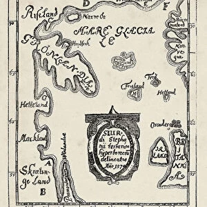
Mounted Print : Map of Tunisia and Algeria 1896


![]()
Mounted Prints from Fine Art Storehouse
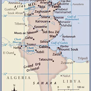
Map of Tunisia and Algeria 1896
Andres Allgemeiner Handatlas - Bielefeld und Leipzig 1896
Unleash your creativity and transform your space into a visual masterpiece!
THEPALMER
Media ID 18356821
10"x8" Mount with 8"x6" Print
Discover the rich history of North Africa with our stunningly detailed Map of Tunisia and Algeria from the Media Storehouse range. This exquisite mounted photo is taken from the Andres Allgemeiner Handatlas published in Bielefeld and Leipzig in 1896 by THEPALMER. The intricate cartography showcases the borders and territories of Tunisia and Algeria during that era, making it a captivating addition to any home or office. Bring a piece of historical cartography into your space and transport yourself back in time with this beautiful and authentic mounted photo.
Printed on 8"x6" paper and suitable for use in a 10"x8" frame (frame not included). Prints are mounted with card both front and back. Featuring a custom cut aperture to match chosen image. Professional 234gsm Fujifilm Crystal Archive DP II paper.
Photo prints supplied in custom cut card mount ready for framing
Estimated Image Size (if not cropped) is 20.3cm x 13.4cm (8" x 5.3")
Estimated Product Size is 25.4cm x 20.3cm (10" x 8")
These are individually made so all sizes are approximate
Artwork printed orientated as per the preview above, with landscape (horizontal) orientation to match the source image.
FEATURES IN THESE COLLECTIONS
> Fine Art Storehouse
> Map
> Historical Maps
> Africa
> Algeria
> Related Images
> Africa
> Tunisia
> Related Images
> Maps and Charts
> Related Images
EDITORS COMMENTS
This print showcases a historical gem, the "Map of Tunisia and Algeria 1896" sourced from Andres Allgemeiner Handatlas - Bielefeld und Leipzig 1896. A true testament to the artistry of cartography, this piece transports us back in time to an era when exploration and discovery were at their peak. The intricate details etched on this map offer a glimpse into the political boundaries, geographical features, and cultural nuances that defined Tunisia and Algeria during the late 19th century. The careful craftsmanship is evident as each contour line, river system, and city placement is meticulously illustrated with precision. As we delve deeper into this visual treasure trove, our imagination takes flight. We can almost envision intrepid explorers embarking on perilous journeys across vast deserts or traders navigating bustling markets within these North African lands. Beyond its historical significance lies an aesthetic appeal that captivates viewers. The sepia tones evoke a sense of nostalgia while adding warmth to any space it graces. Whether displayed in a study or living room, this artwork effortlessly becomes a conversation starter for those who appreciate both history and fine craftsmanship. "The Map of Tunisia and Algeria 1896" by THEPALMER is not just an ordinary print; it's a gateway to another time—a tangible link between past and present. It serves as a reminder of how far we have come while honoring the rich tapestry woven by those who came before us.
MADE IN THE UK
Safe Shipping with 30 Day Money Back Guarantee
FREE PERSONALISATION*
We are proud to offer a range of customisation features including Personalised Captions, Color Filters and Picture Zoom Tools
SECURE PAYMENTS
We happily accept a wide range of payment options so you can pay for the things you need in the way that is most convenient for you
* Options may vary by product and licensing agreement. Zoomed Pictures can be adjusted in the Basket.